You are here: Home > Network List > CI - Caltech Regional Seismic Network Stations List
> Station SCI2 SCI2, San Clemente Is. (NW tip), CA, USA > Earthquake Result Viewer
SCI2 SCI2, San Clemente Is. (NW tip), CA, USA - Earthquake Result Viewer
| Earthquake location: |
Windward Islands |
| Earthquake latitude/longitude: |
15.0/-61.3 |
| Earthquake time(UTC): |
2007/11/29 (333) 19:00:19 GMT |
| Earthquake Depth: |
148 km |
| Earthquake Magnitude: |
6.9 MB, 7.4 MW, 7.4 MW |
| Earthquake Catalog/Contributor: |
WHDF/NEIC |
|
| Network: |
CI Caltech Regional Seismic Network |
| Station: |
SCI2 SCI2, San Clemente Is. (NW tip), CA, USA |
| Lat/Lon: |
32.98 N/118.55 W |
| Elevation: |
199 m |
|
| Distance: |
54.7 deg |
| Az: |
299.92 deg |
| Baz: |
94.724 deg |
| Ray Param: |
0.06480487 |
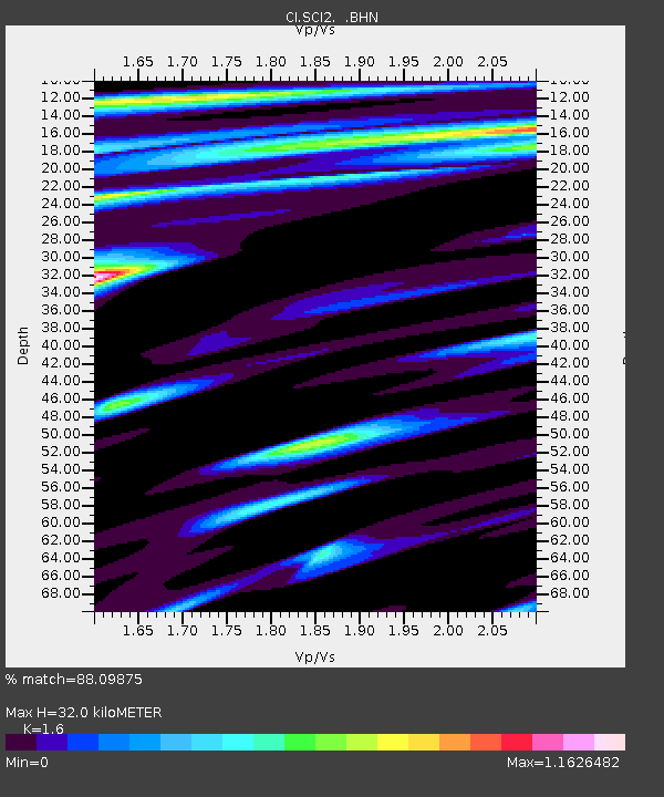
| Estimated Moho Depth: |
32.0 km |
| Estimated Crust Vp/Vs: |
1.60 |
| Assumed Crust Vp: |
6.048 km/s |
| Estimated Crust Vs: |
3.78 km/s |
| Estimated Crust Poisson's Ratio: |
0.18 |
|
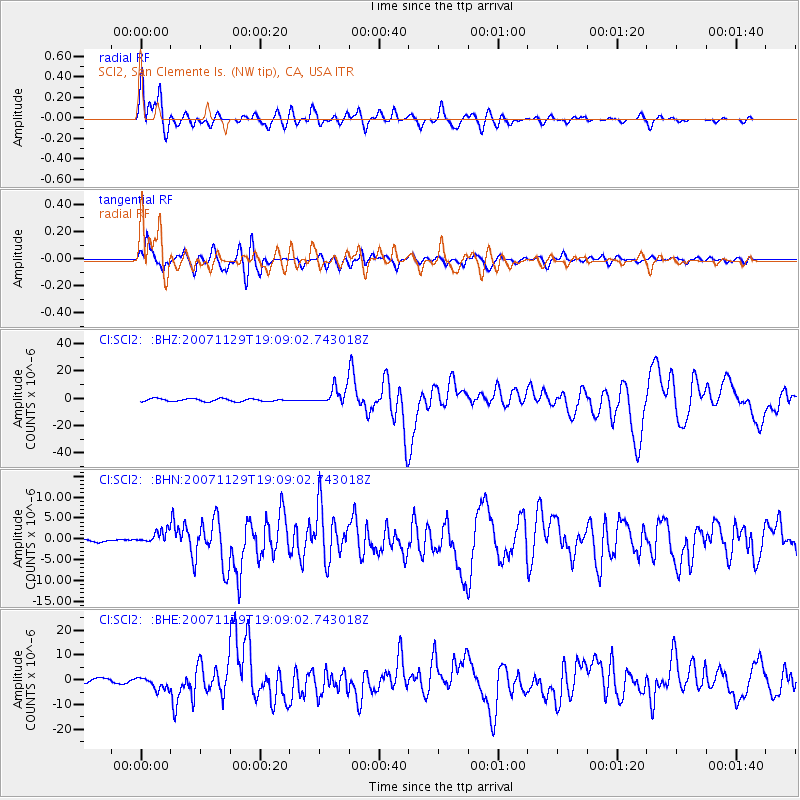
| Radial Match: |
88.09875 % |
| Radial Bump: |
400 |
| Transverse Match: |
84.962616 % |
| Transverse Bump: |
400 |
| SOD ConfigId: |
2564 |
| Insert Time: |
2010-03-05 20:30:57.657 +0000 |
| GWidth: |
2.5 |
| Max Bumps: |
400 |
| Tol: |
0.001 |
|
Signal To Noise
| Channel | StoN | STA | LTA |
| CI:SCI2: :BHN:20071129T19:09:02.743018Z | 2.5530443 | 1.5780082E-6 | 6.1808885E-7 |
| CI:SCI2: :BHE:20071129T19:09:02.743018Z | 2.6339316 | 2.636661E-6 | 1.0010363E-6 |
| CI:SCI2: :BHZ:20071129T19:09:02.743018Z | 6.633465 | 6.5770696E-6 | 9.914984E-7 |
| Arrivals |
| Ps | 3.3 SECOND |
| PpPs | 13 SECOND |
| PsPs/PpSs | 16 SECOND |


