You are here: Home > Network List > CI - Caltech Regional Seismic Network Stations List
> Station SCI2 SCI2, San Clemente Is. (NW tip), CA, USA > Earthquake Result Viewer
SCI2 SCI2, San Clemente Is. (NW tip), CA, USA - Earthquake Result Viewer
| Earthquake location: |
East Of Kuril Islands |
| Earthquake latitude/longitude: |
46.7/155.3 |
| Earthquake time(UTC): |
2006/11/15 (319) 11:34:58 GMT |
| Earthquake Depth: |
10 km |
| Earthquake Magnitude: |
6.4 MB |
| Earthquake Catalog/Contributor: |
WHDF/NEIC |
|
| Network: |
CI Caltech Regional Seismic Network |
| Station: |
SCI2 SCI2, San Clemente Is. (NW tip), CA, USA |
| Lat/Lon: |
32.98 N/118.55 W |
| Elevation: |
199 m |
|
| Distance: |
64.4 deg |
| Az: |
68.386 deg |
| Baz: |
310.365 deg |
| Ray Param: |
0.05892746 |
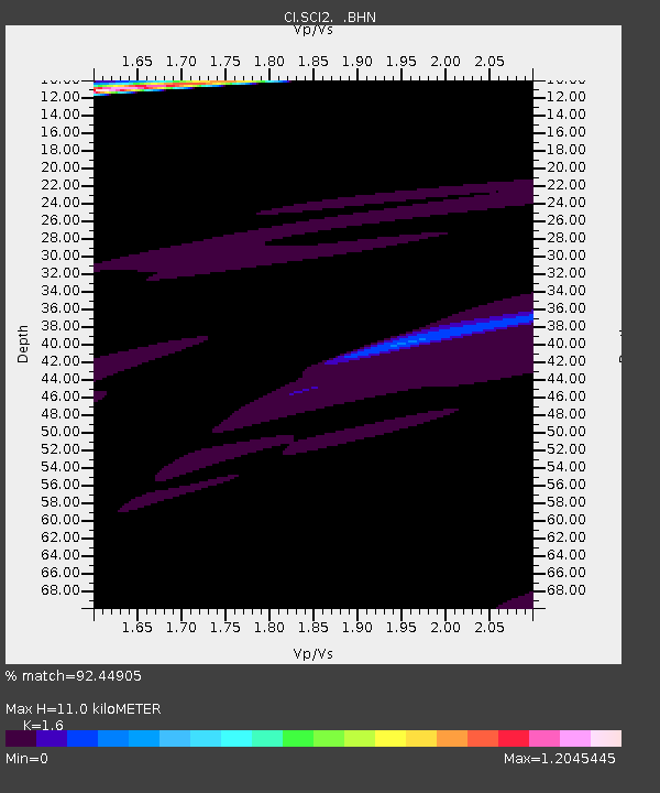
| Estimated Moho Depth: |
11.0 km |
| Estimated Crust Vp/Vs: |
1.60 |
| Assumed Crust Vp: |
6.048 km/s |
| Estimated Crust Vs: |
3.78 km/s |
| Estimated Crust Poisson's Ratio: |
0.18 |
|
| Radial Match: |
92.44905 % |
| Radial Bump: |
335 |
| Transverse Match: |
45.06368 % |
| Transverse Bump: |
400 |
| SOD ConfigId: |
2564 |
| Insert Time: |
2010-03-05 20:31:06.803 +0000 |
| GWidth: |
2.5 |
| Max Bumps: |
400 |
| Tol: |
0.001 |
|

Signal To Noise
| Channel | StoN | STA | LTA |
| CI:SCI2: :BHN:20061115T11:45:03.320002Z | 0.965891 | 7.6710065E-5 | 7.941896E-5 |
| CI:SCI2: :BHE:20061115T11:45:03.320002Z | 1.0522262 | 5.3262094E-5 | 5.061848E-5 |
| CI:SCI2: :BHZ:20061115T11:45:03.320002Z | 1.7317395 | 8.225753E-5 | 4.7499947E-5 |
| Arrivals |
| Ps | 1.1 SECOND |
| PpPs | 4.5 SECOND |
| PsPs/PpSs | 5.7 SECOND |


