You are here: Home > Network List > N4 - Central and EAstern US Network Stations List
> Station N47A Urbana, IN, USA > Earthquake Result Viewer
N47A Urbana, IN, USA - Earthquake Result Viewer
| Earthquake location: |
Central East Pacific Rise |
| Earthquake latitude/longitude: |
-9.1/-109.8 |
| Earthquake time(UTC): |
2016/12/11 (346) 14:33:12 GMT |
| Earthquake Depth: |
10 km |
| Earthquake Magnitude: |
5.7 Mwb |
| Earthquake Catalog/Contributor: |
NEIC PDE/us |
|
| Network: |
N4 Central and EAstern US Network |
| Station: |
N47A Urbana, IN, USA |
| Lat/Lon: |
40.88 N/85.69 W |
| Elevation: |
252 m |
|
| Distance: |
54.5 deg |
| Az: |
22.395 deg |
| Baz: |
209.748 deg |
| Ray Param: |
0.06539786 |
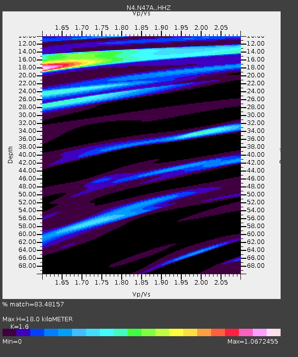
| Estimated Moho Depth: |
18.0 km |
| Estimated Crust Vp/Vs: |
1.60 |
| Assumed Crust Vp: |
6.498 km/s |
| Estimated Crust Vs: |
4.061 km/s |
| Estimated Crust Poisson's Ratio: |
0.18 |
|
| Radial Match: |
83.48157 % |
| Radial Bump: |
400 |
| Transverse Match: |
69.08629 % |
| Transverse Bump: |
388 |
| SOD ConfigId: |
11737051 |
| Insert Time: |
2019-04-26 07:38:06.041 +0000 |
| GWidth: |
2.5 |
| Max Bumps: |
400 |
| Tol: |
0.001 |
|

Signal To Noise
| Channel | StoN | STA | LTA |
| N4:N47A: :HHZ:20161211T14:42:09.750015Z | 2.0335536 | 1.3564894E-6 | 6.6705365E-7 |
| N4:N47A: :HHN:20161211T14:42:09.750015Z | 1.240164 | 8.5798234E-7 | 6.918297E-7 |
| N4:N47A: :HHE:20161211T14:42:09.750015Z | 0.22455812 | 1.5004332E-7 | 6.681714E-7 |
| Arrivals |
| Ps | 1.8 SECOND |
| PpPs | 6.8 SECOND |
| PsPs/PpSs | 8.5 SECOND |


