You are here: Home > Network List > CB - China National Seismic Network Stations List
> Station GOM Geermu,Qinghai Province > Earthquake Result Viewer
GOM Geermu,Qinghai Province - Earthquake Result Viewer
| Earthquake location: |
Mariana Islands Region |
| Earthquake latitude/longitude: |
21.3/144.4 |
| Earthquake time(UTC): |
2016/12/14 (349) 02:01:23 GMT |
| Earthquake Depth: |
28 km |
| Earthquake Magnitude: |
6.0 Mww |
| Earthquake Catalog/Contributor: |
NEIC PDE/us |
|
| Network: |
CB China National Seismic Network |
| Station: |
GOM Geermu,Qinghai Province |
| Lat/Lon: |
36.20 N/94.81 E |
| Elevation: |
3121 m |
|
| Distance: |
45.5 deg |
| Az: |
300.238 deg |
| Baz: |
95.097 deg |
| Ray Param: |
0.07119957 |
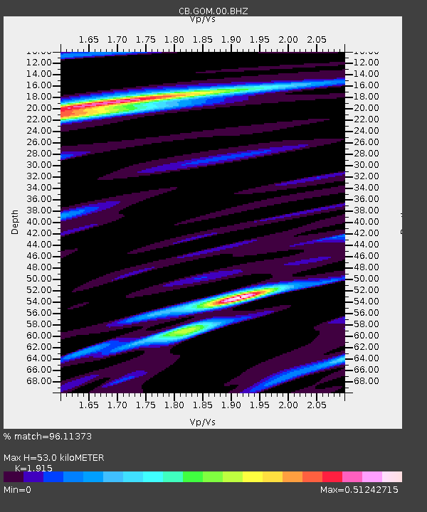
| Estimated Moho Depth: |
53.0 km |
| Estimated Crust Vp/Vs: |
1.91 |
| Assumed Crust Vp: |
6.385 km/s |
| Estimated Crust Vs: |
3.334 km/s |
| Estimated Crust Poisson's Ratio: |
0.31 |
|
| Radial Match: |
96.11373 % |
| Radial Bump: |
195 |
| Transverse Match: |
84.05318 % |
| Transverse Bump: |
400 |
| SOD ConfigId: |
11737051 |
| Insert Time: |
2019-04-26 07:45:29.786 +0000 |
| GWidth: |
2.5 |
| Max Bumps: |
400 |
| Tol: |
0.001 |
|

Signal To Noise
| Channel | StoN | STA | LTA |
| CB:GOM:00:BHZ:20161214T02:09:09.379995Z | 1.4782254 | 1.4379953E-7 | 9.727849E-8 |
| CB:GOM:00:BHN:20161214T02:09:09.379995Z | 0.664988 | 3.429585E-8 | 5.157364E-8 |
| CB:GOM:00:BHE:20161214T02:09:09.379995Z | 3.678168 | 9.78096E-8 | 2.6591932E-8 |
| Arrivals |
| Ps | 8.0 SECOND |
| PpPs | 23 SECOND |
| PsPs/PpSs | 31 SECOND |


