You are here: Home > Network List > CI - Caltech Regional Seismic Network Stations List
> Station SMM Simmler, CA, USA > Earthquake Result Viewer
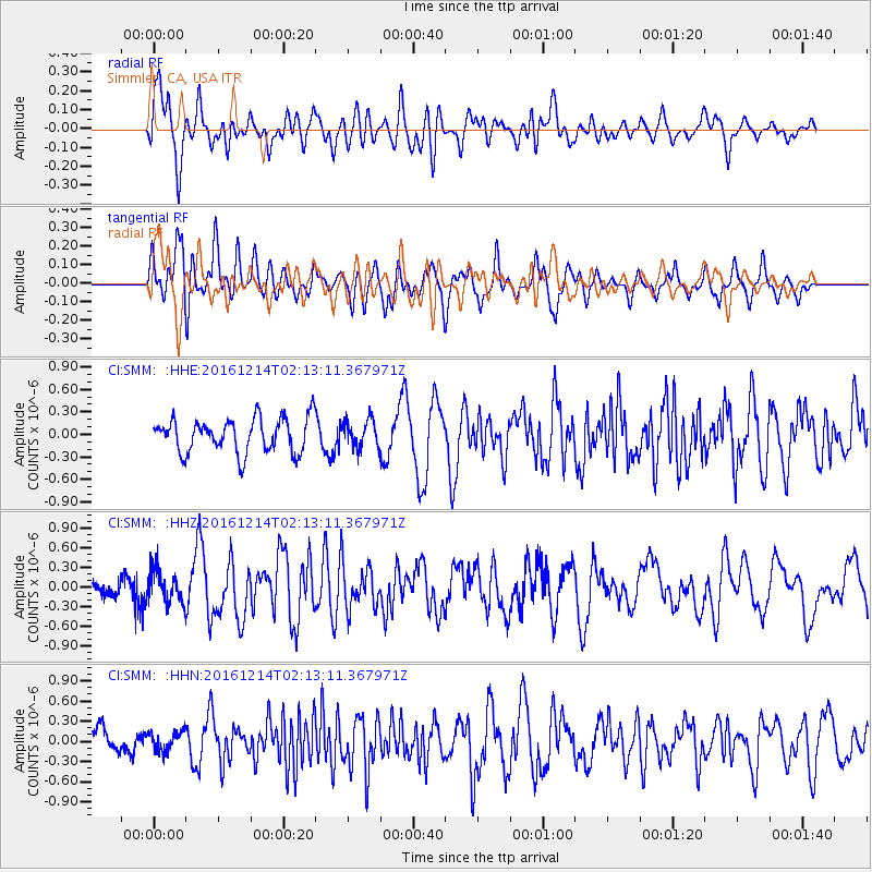
SMM Simmler, CA, USA - Earthquake Result Viewer
*The percent match for this event was below the threshold and hence no stack was calculated.
| Earthquake location: |
Mariana Islands Region |
| Earthquake latitude/longitude: |
21.3/144.4 |
| Earthquake time(UTC): |
2016/12/14 (349) 02:01:23 GMT |
| Earthquake Depth: |
28 km |
| Earthquake Magnitude: |
6.0 Mww |
| Earthquake Catalog/Contributor: |
NEIC PDE/us |
|
| Network: |
CI Caltech Regional Seismic Network |
| Station: |
SMM Simmler, CA, USA |
| Lat/Lon: |
35.31 N/120.00 W |
| Elevation: |
599 m |
|
| Distance: |
82.3 deg |
| Az: |
55.214 deg |
| Baz: |
290.528 deg |
| Ray Param: |
$rayparam |
*The percent match for this event was below the threshold and hence was not used in the summary stack. |
|
| Radial Match: |
69.08067 % |
| Radial Bump: |
400 |
| Transverse Match: |
64.04953 % |
| Transverse Bump: |
400 |
| SOD ConfigId: |
11737051 |
| Insert Time: |
2019-04-26 07:46:02.388 +0000 |
| GWidth: |
2.5 |
| Max Bumps: |
400 |
| Tol: |
0.001 |
|
Signal To Noise
| Channel | StoN | STA | LTA |
| CI:SMM: :HHZ:20161214T02:13:11.367971Z | 1.7891018 | 2.4134104E-7 | 1.3489507E-7 |
| CI:SMM: :HHN:20161214T02:13:11.367971Z | 0.78199005 | 1.3754043E-7 | 1.7588512E-7 |
| CI:SMM: :HHE:20161214T02:13:11.367971Z | 0.8169651 | 1.900479E-7 | 2.3262672E-7 |
| Arrivals |
| Ps | |
| PpPs | |
| PsPs/PpSs | |


