You are here: Home > Network List > TA - USArray Transportable Network (new EarthScope stations) Stations List
> Station F26K Sheenjek River, AK, USA > Earthquake Result Viewer
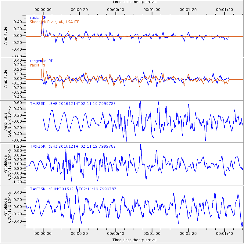
F26K Sheenjek River, AK, USA - Earthquake Result Viewer
*The percent match for this event was below the threshold and hence no stack was calculated.
| Earthquake location: |
Mariana Islands Region |
| Earthquake latitude/longitude: |
21.3/144.4 |
| Earthquake time(UTC): |
2016/12/14 (349) 02:01:23 GMT |
| Earthquake Depth: |
28 km |
| Earthquake Magnitude: |
6.0 Mww |
| Earthquake Catalog/Contributor: |
NEIC PDE/us |
|
| Network: |
TA USArray Transportable Network (new EarthScope stations) |
| Station: |
F26K Sheenjek River, AK, USA |
| Lat/Lon: |
67.69 N/144.15 W |
| Elevation: |
683 m |
|
| Distance: |
63.4 deg |
| Az: |
23.862 deg |
| Baz: |
261.219 deg |
| Ray Param: |
$rayparam |
*The percent match for this event was below the threshold and hence was not used in the summary stack. |
|
| Radial Match: |
55.57176 % |
| Radial Bump: |
400 |
| Transverse Match: |
48.08897 % |
| Transverse Bump: |
335 |
| SOD ConfigId: |
11737051 |
| Insert Time: |
2019-04-26 07:48:41.774 +0000 |
| GWidth: |
2.5 |
| Max Bumps: |
400 |
| Tol: |
0.001 |
|
Signal To Noise
| Channel | StoN | STA | LTA |
| TA:F26K: :BHZ:20161214T02:11:19.799978Z | 2.93254 | 3.080911E-7 | 1.0505948E-7 |
| TA:F26K: :BHN:20161214T02:11:19.799978Z | 0.7195165 | 1.291761E-7 | 1.7953181E-7 |
| TA:F26K: :BHE:20161214T02:11:19.799978Z | 0.6250998 | 1.2609303E-7 | 2.0171665E-7 |
| Arrivals |
| Ps | |
| PpPs | |
| PsPs/PpSs | |


