You are here: Home > Network List > CI - Caltech Regional Seismic Network Stations List
> Station SWS Sam W. Stewart, Westmorland, CA, USA > Earthquake Result Viewer
SWS Sam W. Stewart, Westmorland, CA, USA - Earthquake Result Viewer

| Earthquake location: |
Costa Rica |
| Earthquake latitude/longitude: |
10.8/-86.0 |
| Earthquake time(UTC): |
2004/04/29 (120) 00:57:21 GMT |
| Earthquake Depth: |
10 km |
| Earthquake Magnitude: |
5.6 MB, 6.0 MS, 6.2 MW, 6.2 MW |
| Earthquake Catalog/Contributor: |
WHDF/NEIC |
|
| Network: |
CI Caltech Regional Seismic Network |
| Station: |
SWS Sam W. Stewart, Westmorland, CA, USA |
| Lat/Lon: |
32.94 N/115.80 W |
| Elevation: |
140 m |
|
| Distance: |
35.1 deg |
| Az: |
313.445 deg |
| Baz: |
121.973 deg |
| Ray Param: |
0.077377565 |
| Estimated Moho Depth: |
19.25 km |
| Estimated Crust Vp/Vs: |
1.70 |
| Assumed Crust Vp: |
6.155 km/s |
| Estimated Crust Vs: |
3.626 km/s |
| Estimated Crust Poisson's Ratio: |
0.23 |
|
| Radial Match: |
88.657974 % |
| Radial Bump: |
388 |
| Transverse Match: |
81.11692 % |
| Transverse Bump: |
400 |
| SOD ConfigId: |
2459 |
| Insert Time: |
2010-03-05 20:32:57.781 +0000 |
| GWidth: |
2.5 |
| Max Bumps: |
400 |
| Tol: |
0.001 |
|
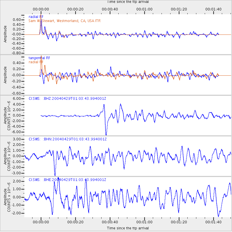
Signal To Noise
| Channel | StoN | STA | LTA |
| CI:SWS: :BHN:20040429T01:03:43.994001Z | 2.0677998 | 4.568938E-7 | 2.209565E-7 |
| CI:SWS: :BHE:20040429T01:03:43.994001Z | 0.9338098 | 3.1170086E-7 | 3.337948E-7 |
| CI:SWS: :BHZ:20040429T01:03:43.994001Z | 3.4428735 | 4.52607E-7 | 1.3146199E-7 |
| Arrivals |
| Ps | 2.3 SECOND |
| PpPs | 7.8 SECOND |
| PsPs/PpSs | 10 SECOND |


