You are here: Home > Network List > TA - USArray Transportable Network (new EarthScope stations) Stations List
> Station TPFO Pinon Flats, CA, USA > Earthquake Result Viewer
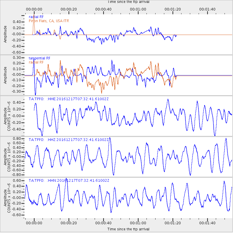
TPFO Pinon Flats, CA, USA - Earthquake Result Viewer
*The percent match for this event was below the threshold and hence no stack was calculated.
| Earthquake location: |
Near Coast Of Peru |
| Earthquake latitude/longitude: |
-10.9/-78.8 |
| Earthquake time(UTC): |
2016/12/17 (352) 07:23:30 GMT |
| Earthquake Depth: |
38 km |
| Earthquake Magnitude: |
5.0 mb |
| Earthquake Catalog/Contributor: |
NEIC PDE/us |
|
| Network: |
TA USArray Transportable Network (new EarthScope stations) |
| Station: |
TPFO Pinon Flats, CA, USA |
| Lat/Lon: |
33.61 N/116.45 W |
| Elevation: |
1275 m |
|
| Distance: |
56.9 deg |
| Az: |
322.526 deg |
| Baz: |
134.271 deg |
| Ray Param: |
$rayparam |
*The percent match for this event was below the threshold and hence was not used in the summary stack. |
|
| Radial Match: |
64.6326 % |
| Radial Bump: |
400 |
| Transverse Match: |
62.614357 % |
| Transverse Bump: |
400 |
| SOD ConfigId: |
11737051 |
| Insert Time: |
2019-04-26 08:05:51.835 +0000 |
| GWidth: |
2.5 |
| Max Bumps: |
400 |
| Tol: |
0.001 |
|
Signal To Noise
| Channel | StoN | STA | LTA |
| TA:TPFO: :HHZ:20161217T07:32:41.61002Z | 1.2816738 | 3.5365824E-7 | 2.7593467E-7 |
| TA:TPFO: :HHN:20161217T07:32:41.61002Z | 0.6744177 | 1.456328E-7 | 2.1593858E-7 |
| TA:TPFO: :HHE:20161217T07:32:41.61002Z | 1.118823 | 2.71829E-7 | 2.429598E-7 |
| Arrivals |
| Ps | |
| PpPs | |
| PsPs/PpSs | |


