You are here: Home > Network List > CI - Caltech Regional Seismic Network Stations List
> Station SWS Sam W. Stewart, Westmorland, CA, USA > Earthquake Result Viewer
SWS Sam W. Stewart, Westmorland, CA, USA - Earthquake Result Viewer
| Earthquake location: |
Solomon Islands |
| Earthquake latitude/longitude: |
-10.5/161.3 |
| Earthquake time(UTC): |
2008/06/03 (155) 16:20:50 GMT |
| Earthquake Depth: |
84 km |
| Earthquake Magnitude: |
6.2 MB, 6.2 MW, 6.2 MW |
| Earthquake Catalog/Contributor: |
WHDF/NEIC |
|
| Network: |
CI Caltech Regional Seismic Network |
| Station: |
SWS Sam W. Stewart, Westmorland, CA, USA |
| Lat/Lon: |
32.94 N/115.80 W |
| Elevation: |
140 m |
|
| Distance: |
89.8 deg |
| Az: |
56.565 deg |
| Baz: |
257.416 deg |
| Ray Param: |
0.041703966 |
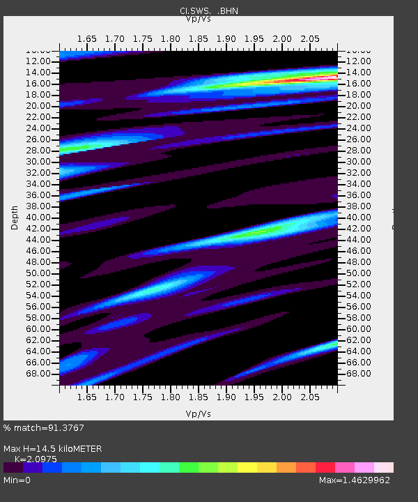
| Estimated Moho Depth: |
14.5 km |
| Estimated Crust Vp/Vs: |
2.10 |
| Assumed Crust Vp: |
6.155 km/s |
| Estimated Crust Vs: |
2.934 km/s |
| Estimated Crust Poisson's Ratio: |
0.35 |
|
| Radial Match: |
91.3767 % |
| Radial Bump: |
400 |
| Transverse Match: |
83.373566 % |
| Transverse Bump: |
400 |
| SOD ConfigId: |
2504 |
| Insert Time: |
2010-03-05 20:33:27.145 +0000 |
| GWidth: |
2.5 |
| Max Bumps: |
400 |
| Tol: |
0.001 |
|
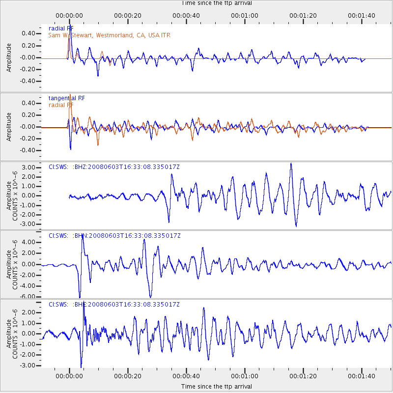
Signal To Noise
| Channel | StoN | STA | LTA |
| CI:SWS: :BHN:20080603T16:33:08.335017Z | 30.459583 | 2.569217E-6 | 8.43484E-8 |
| CI:SWS: :BHE:20080603T16:33:08.335017Z | 4.562432 | 1.024738E-6 | 2.2460347E-7 |
| CI:SWS: :BHZ:20080603T16:33:08.335017Z | 5.3319473 | 9.241789E-7 | 1.7332859E-7 |
| Arrivals |
| Ps | 2.6 SECOND |
| PpPs | 7.2 SECOND |
| PsPs/PpSs | 9.8 SECOND |


