You are here: Home > Network List > CI - Caltech Regional Seismic Network Stations List
> Station SWS Sam W. Stewart, Westmorland, CA, USA > Earthquake Result Viewer
SWS Sam W. Stewart, Westmorland, CA, USA - Earthquake Result Viewer

| Earthquake location: |
Off East Coast Of Honshu, Japan |
| Earthquake latitude/longitude: |
37.6/142.2 |
| Earthquake time(UTC): |
2008/07/19 (201) 02:39:28 GMT |
| Earthquake Depth: |
22 km |
| Earthquake Magnitude: |
6.2 MB, 7.0 MS, 7.0 MW, 6.9 MW |
| Earthquake Catalog/Contributor: |
WHDF/NEIC |
|
| Network: |
CI Caltech Regional Seismic Network |
| Station: |
SWS Sam W. Stewart, Westmorland, CA, USA |
| Lat/Lon: |
32.94 N/115.80 W |
| Elevation: |
140 m |
|
| Distance: |
79.1 deg |
| Az: |
56.903 deg |
| Baz: |
307.646 deg |
| Ray Param: |
0.049190834 |
| Estimated Moho Depth: |
16.5 km |
| Estimated Crust Vp/Vs: |
1.94 |
| Assumed Crust Vp: |
6.155 km/s |
| Estimated Crust Vs: |
3.172 km/s |
| Estimated Crust Poisson's Ratio: |
0.32 |
|
| Radial Match: |
93.11804 % |
| Radial Bump: |
400 |
| Transverse Match: |
72.64749 % |
| Transverse Bump: |
400 |
| SOD ConfigId: |
2504 |
| Insert Time: |
2010-03-05 20:33:31.236 +0000 |
| GWidth: |
2.5 |
| Max Bumps: |
400 |
| Tol: |
0.001 |
|
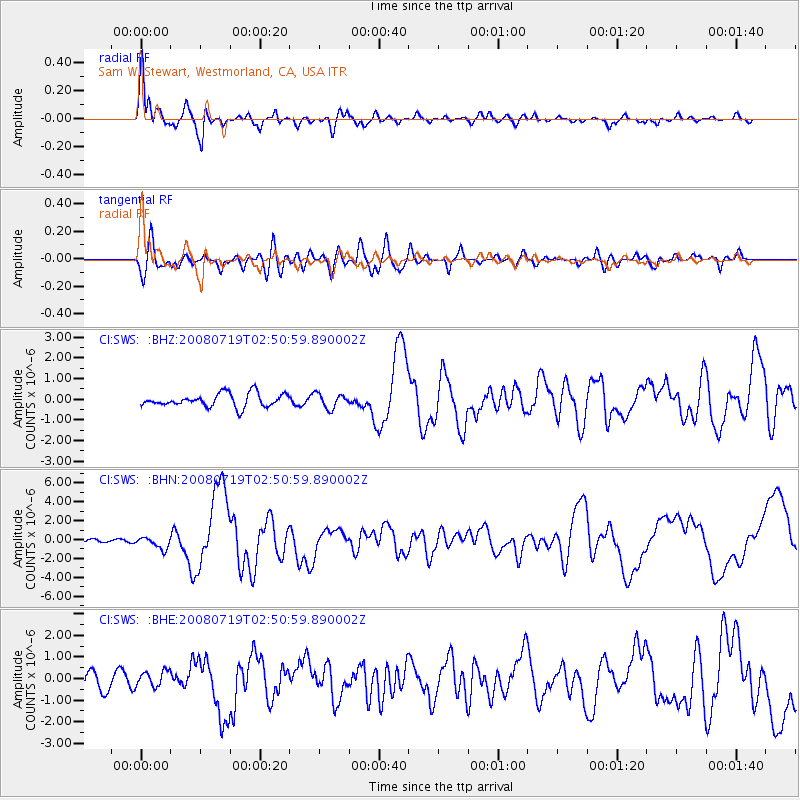
Signal To Noise
| Channel | StoN | STA | LTA |
| CI:SWS: :BHN:20080719T02:50:59.890002Z | 2.8715224 | 6.305715E-7 | 2.1959484E-7 |
| CI:SWS: :BHE:20080719T02:50:59.890002Z | 1.1376792 | 3.6208348E-7 | 3.1826502E-7 |
| CI:SWS: :BHZ:20080719T02:50:59.890002Z | 1.1027969 | 3.4999874E-7 | 3.173737E-7 |
| Arrivals |
| Ps | 2.6 SECOND |
| PpPs | 7.7 SECOND |
| PsPs/PpSs | 10 SECOND |


