You are here: Home > Network List > CI - Caltech Regional Seismic Network Stations List
> Station SWS Sam W. Stewart, Westmorland, CA, USA > Earthquake Result Viewer
SWS Sam W. Stewart, Westmorland, CA, USA - Earthquake Result Viewer
| Earthquake location: |
Kermadec Islands, New Zealand |
| Earthquake latitude/longitude: |
-29.8/-177.7 |
| Earthquake time(UTC): |
2008/09/29 (273) 15:19:31 GMT |
| Earthquake Depth: |
36 km |
| Earthquake Magnitude: |
6.5 MB, 6.7 MS, 7.0 MW, 7.0 MW |
| Earthquake Catalog/Contributor: |
WHDF/NEIC |
|
| Network: |
CI Caltech Regional Seismic Network |
| Station: |
SWS Sam W. Stewart, Westmorland, CA, USA |
| Lat/Lon: |
32.94 N/115.80 W |
| Elevation: |
140 m |
|
| Distance: |
85.6 deg |
| Az: |
48.066 deg |
| Baz: |
230.29 deg |
| Ray Param: |
0.044623233 |
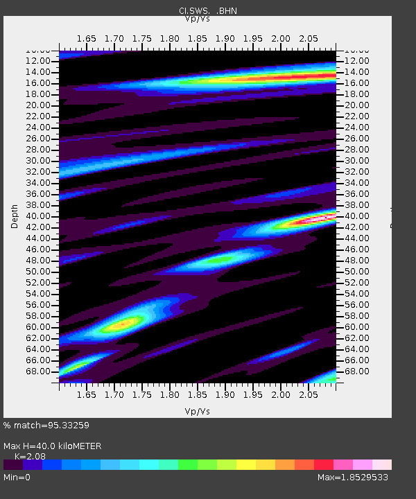
| Estimated Moho Depth: |
40.0 km |
| Estimated Crust Vp/Vs: |
2.08 |
| Assumed Crust Vp: |
6.155 km/s |
| Estimated Crust Vs: |
2.959 km/s |
| Estimated Crust Poisson's Ratio: |
0.35 |
|
| Radial Match: |
95.33259 % |
| Radial Bump: |
400 |
| Transverse Match: |
94.037735 % |
| Transverse Bump: |
400 |
| SOD ConfigId: |
2560 |
| Insert Time: |
2010-03-05 20:33:43.618 +0000 |
| GWidth: |
2.5 |
| Max Bumps: |
400 |
| Tol: |
0.001 |
|
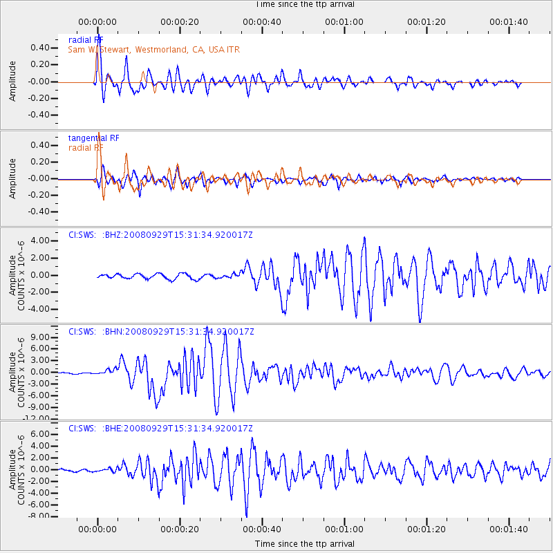
Signal To Noise
| Channel | StoN | STA | LTA |
| CI:SWS: :BHN:20080929T15:31:34.920017Z | 4.74405 | 7.680526E-7 | 1.6189809E-7 |
| CI:SWS: :BHE:20080929T15:31:34.920017Z | 1.1422193 | 2.9507828E-7 | 2.583377E-7 |
| CI:SWS: :BHZ:20080929T15:31:34.920017Z | 0.81944114 | 2.4444054E-7 | 2.9830153E-7 |
| Arrivals |
| Ps | 7.2 SECOND |
| PpPs | 20 SECOND |
| PsPs/PpSs | 27 SECOND |


