You are here: Home > Network List > AV - Alaska Volcano Observatory Stations List
> Station MAPS Pakushin Southeast, Makushin Volcano, Alaska > Earthquake Result Viewer
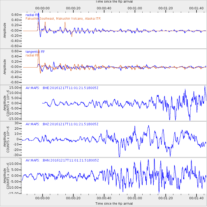
MAPS Pakushin Southeast, Makushin Volcano, Alaska - Earthquake Result Viewer
*The percent match for this event was below the threshold and hence no stack was calculated.
| Earthquake location: |
New Ireland Region, P.N.G. |
| Earthquake latitude/longitude: |
-4.5/153.6 |
| Earthquake time(UTC): |
2016/12/17 (352) 10:51:11 GMT |
| Earthquake Depth: |
73 km |
| Earthquake Magnitude: |
8.0 Mi |
| Earthquake Catalog/Contributor: |
NEIC PDE/pt |
|
| Network: |
AV Alaska Volcano Observatory |
| Station: |
MAPS Pakushin Southeast, Makushin Volcano, Alaska |
| Lat/Lon: |
53.81 N/166.94 W |
| Elevation: |
333 m |
|
| Distance: |
66.8 deg |
| Az: |
24.223 deg |
| Baz: |
223.607 deg |
| Ray Param: |
$rayparam |
*The percent match for this event was below the threshold and hence was not used in the summary stack. |
|
| Radial Match: |
87.783646 % |
| Radial Bump: |
400 |
| Transverse Match: |
70.91025 % |
| Transverse Bump: |
400 |
| SOD ConfigId: |
11737051 |
| Insert Time: |
2019-04-26 08:10:21.349 +0000 |
| GWidth: |
2.5 |
| Max Bumps: |
400 |
| Tol: |
0.001 |
|
Signal To Noise
| Channel | StoN | STA | LTA |
| AV:MAPS: :BHZ:20161217T11:01:21.518005Z | 3.4585805 | 3.8241033E-6 | 1.1056858E-6 |
| AV:MAPS: :BHN:20161217T11:01:21.518005Z | 1.1487354 | 1.78782E-6 | 1.5563376E-6 |
| AV:MAPS: :BHE:20161217T11:01:21.518005Z | 1.3015001 | 1.9357851E-6 | 1.4873492E-6 |
| Arrivals |
| Ps | |
| PpPs | |
| PsPs/PpSs | |


