You are here: Home > Network List > CI - Caltech Regional Seismic Network Stations List
> Station SWS Sam W. Stewart, Westmorland, CA, USA > Earthquake Result Viewer
SWS Sam W. Stewart, Westmorland, CA, USA - Earthquake Result Viewer

| Earthquake location: |
Vanuatu Islands |
| Earthquake latitude/longitude: |
-20.8/169.4 |
| Earthquake time(UTC): |
2007/03/25 (084) 01:08:19 GMT |
| Earthquake Depth: |
35 km |
| Earthquake Magnitude: |
5.9 MB, 7.1 MS, 6.9 MW |
| Earthquake Catalog/Contributor: |
WHDF/NEIC |
|
| Network: |
CI Caltech Regional Seismic Network |
| Station: |
SWS Sam W. Stewart, Westmorland, CA, USA |
| Lat/Lon: |
32.94 N/115.80 W |
| Elevation: |
140 m |
|
| Distance: |
89.1 deg |
| Az: |
54.268 deg |
| Baz: |
244.618 deg |
| Ray Param: |
0.042023066 |
| Estimated Moho Depth: |
47.25 km |
| Estimated Crust Vp/Vs: |
1.96 |
| Assumed Crust Vp: |
6.155 km/s |
| Estimated Crust Vs: |
3.136 km/s |
| Estimated Crust Poisson's Ratio: |
0.32 |
|
| Radial Match: |
96.20613 % |
| Radial Bump: |
358 |
| Transverse Match: |
49.94338 % |
| Transverse Bump: |
400 |
| SOD ConfigId: |
2564 |
| Insert Time: |
2010-03-05 20:34:16.171 +0000 |
| GWidth: |
2.5 |
| Max Bumps: |
400 |
| Tol: |
0.001 |
|
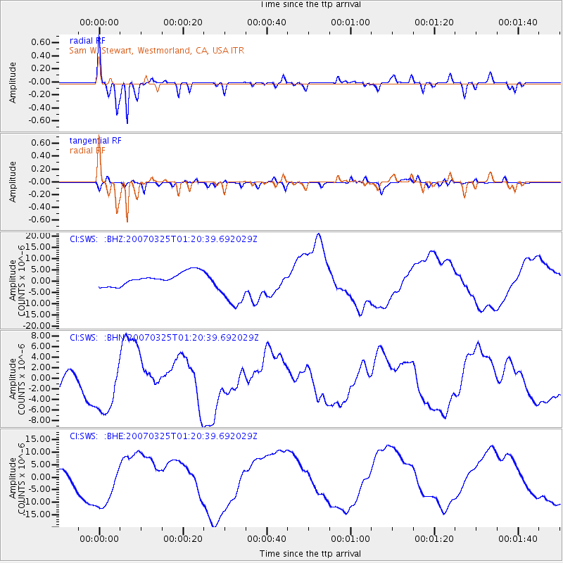
Signal To Noise
| Channel | StoN | STA | LTA |
| CI:SWS: :BHN:20070325T01:20:39.692029Z | 1.7344743 | 5.4426278E-6 | 3.137912E-6 |
| CI:SWS: :BHE:20070325T01:20:39.692029Z | 4.281224 | 9.962202E-6 | 2.326952E-6 |
| CI:SWS: :BHZ:20070325T01:20:39.692029Z | 3.535879 | 1.0025334E-5 | 2.8353159E-6 |
| Arrivals |
| Ps | 7.5 SECOND |
| PpPs | 22 SECOND |
| PsPs/PpSs | 30 SECOND |


