You are here: Home > Network List > CI - Caltech Regional Seismic Network Stations List
> Station SWS Sam W. Stewart, Westmorland, CA, USA > Earthquake Result Viewer
SWS Sam W. Stewart, Westmorland, CA, USA - Earthquake Result Viewer
| Earthquake location: |
East Of Kuril Islands |
| Earthquake latitude/longitude: |
46.2/154.5 |
| Earthquake time(UTC): |
2007/01/13 (013) 04:23:21 GMT |
| Earthquake Depth: |
10 km |
| Earthquake Magnitude: |
7.3 MB, 8.2 MS, 8.1 MW, 7.9 MW |
| Earthquake Catalog/Contributor: |
WHDF/NEIC |
|
| Network: |
CI Caltech Regional Seismic Network |
| Station: |
SWS Sam W. Stewart, Westmorland, CA, USA |
| Lat/Lon: |
32.94 N/115.80 W |
| Elevation: |
140 m |
|
| Distance: |
66.9 deg |
| Az: |
66.123 deg |
| Baz: |
311.001 deg |
| Ray Param: |
0.057332423 |
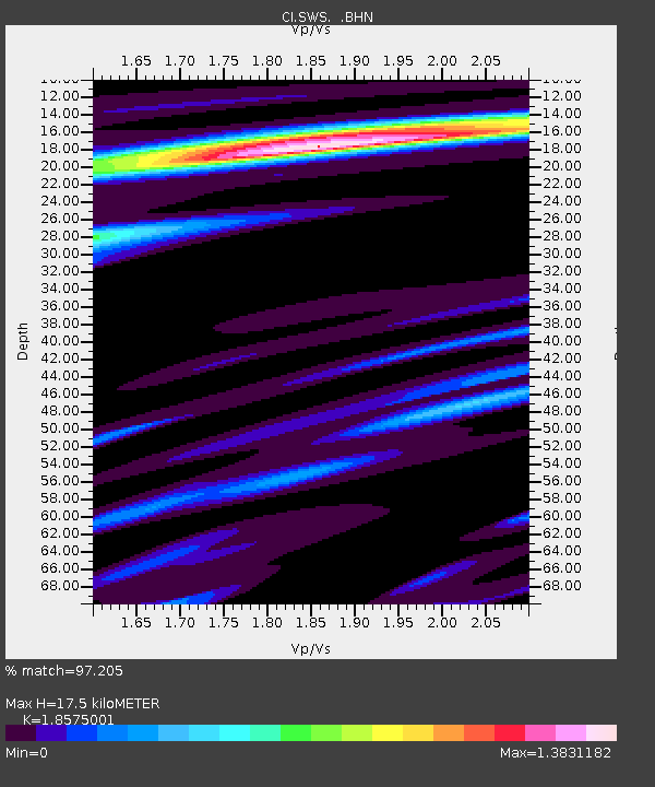
| Estimated Moho Depth: |
17.5 km |
| Estimated Crust Vp/Vs: |
1.86 |
| Assumed Crust Vp: |
6.155 km/s |
| Estimated Crust Vs: |
3.313 km/s |
| Estimated Crust Poisson's Ratio: |
0.30 |
|
| Radial Match: |
97.205 % |
| Radial Bump: |
397 |
| Transverse Match: |
92.64363 % |
| Transverse Bump: |
400 |
| SOD ConfigId: |
2564 |
| Insert Time: |
2010-03-05 20:34:21.304 +0000 |
| GWidth: |
2.5 |
| Max Bumps: |
400 |
| Tol: |
0.001 |
|

Signal To Noise
| Channel | StoN | STA | LTA |
| CI:SWS: :BHN:20070113T04:33:42.042019Z | 2.597738 | 1.0814281E-6 | 4.1629607E-7 |
| CI:SWS: :BHE:20070113T04:33:42.042019Z | 2.271844 | 9.322041E-7 | 4.1032928E-7 |
| CI:SWS: :BHZ:20070113T04:33:42.042019Z | 13.6169 | 2.6213397E-6 | 1.9250633E-7 |
| Arrivals |
| Ps | 2.5 SECOND |
| PpPs | 7.8 SECOND |
| PsPs/PpSs | 10 SECOND |


