You are here: Home > Network List > CI - Caltech Regional Seismic Network Stations List
> Station SDD SDD, Mission Viejo, CA, USA > Earthquake Result Viewer
SDD SDD, Mission Viejo, CA, USA - Earthquake Result Viewer
| Earthquake location: |
Fiji Islands Region |
| Earthquake latitude/longitude: |
-14.4/-177.3 |
| Earthquake time(UTC): |
2005/08/07 (219) 11:35:26 GMT |
| Earthquake Depth: |
10 km |
| Earthquake Magnitude: |
5.7 MB, 5.9 MS, 6.0 MW, 6.0 MW |
| Earthquake Catalog/Contributor: |
WHDF/NEIC |
|
| Network: |
CI Caltech Regional Seismic Network |
| Station: |
SDD SDD, Mission Viejo, CA, USA |
| Lat/Lon: |
33.55 N/117.66 W |
| Elevation: |
120 m |
|
| Distance: |
74.2 deg |
| Az: |
48.492 deg |
| Baz: |
240.314 deg |
| Ray Param: |
0.052506275 |
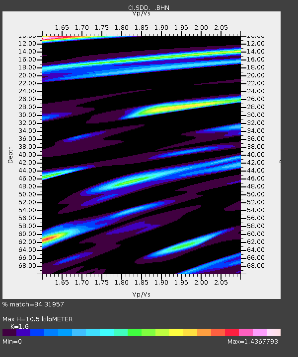
| Estimated Moho Depth: |
10.5 km |
| Estimated Crust Vp/Vs: |
1.60 |
| Assumed Crust Vp: |
6.264 km/s |
| Estimated Crust Vs: |
3.915 km/s |
| Estimated Crust Poisson's Ratio: |
0.18 |
|
| Radial Match: |
84.31957 % |
| Radial Bump: |
400 |
| Transverse Match: |
68.567505 % |
| Transverse Bump: |
400 |
| SOD ConfigId: |
2475 |
| Insert Time: |
2010-02-26 00:56:42.589 +0000 |
| GWidth: |
2.5 |
| Max Bumps: |
400 |
| Tol: |
0.001 |
|
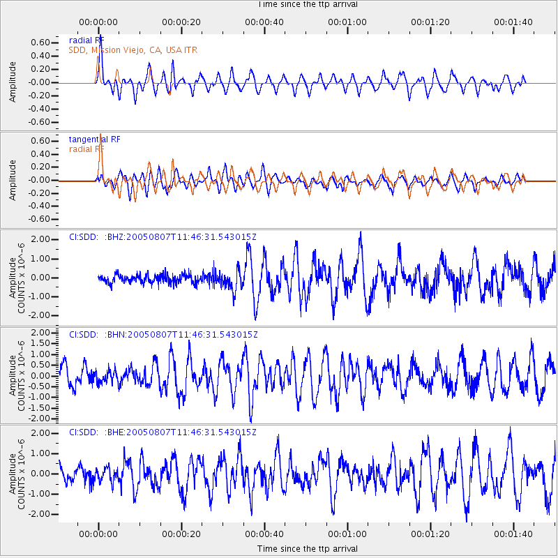
Signal To Noise
| Channel | StoN | STA | LTA |
| CI:SDD: :BHN:20050807T11:46:31.543015Z | 0.74695235 | 2.7095965E-7 | 3.6275355E-7 |
| CI:SDD: :BHE:20050807T11:46:31.543015Z | 0.9658507 | 3.262267E-7 | 3.37761E-7 |
| CI:SDD: :BHZ:20050807T11:46:31.543015Z | 2.3696902 | 5.0435347E-7 | 2.128352E-7 |
| Arrivals |
| Ps | 1.0 SECOND |
| PpPs | 4.2 SECOND |
| PsPs/PpSs | 5.2 SECOND |


