You are here: Home > Network List > TA - USArray Transportable Network (new EarthScope stations) Stations List
> Station J26L Joseph Creek, AK, USA > Earthquake Result Viewer
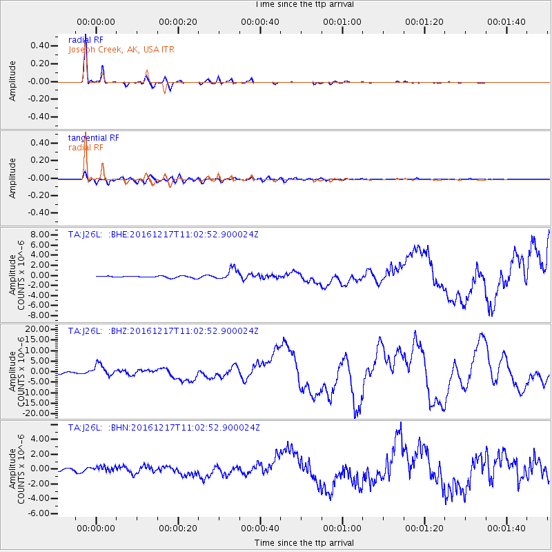
J26L Joseph Creek, AK, USA - Earthquake Result Viewer
*The percent match for this event was below the threshold and hence no stack was calculated.
| Earthquake location: |
New Ireland Region, P.N.G. |
| Earthquake latitude/longitude: |
-4.5/153.6 |
| Earthquake time(UTC): |
2016/12/17 (352) 10:51:11 GMT |
| Earthquake Depth: |
73 km |
| Earthquake Magnitude: |
8.0 Mi |
| Earthquake Catalog/Contributor: |
NEIC PDE/pt |
|
| Network: |
TA USArray Transportable Network (new EarthScope stations) |
| Station: |
J26L Joseph Creek, AK, USA |
| Lat/Lon: |
64.50 N/143.56 W |
| Elevation: |
1144 m |
|
| Distance: |
82.7 deg |
| Az: |
22.851 deg |
| Baz: |
243.439 deg |
| Ray Param: |
$rayparam |
*The percent match for this event was below the threshold and hence was not used in the summary stack. |
|
| Radial Match: |
98.52505 % |
| Radial Bump: |
255 |
| Transverse Match: |
84.53146 % |
| Transverse Bump: |
400 |
| SOD ConfigId: |
11737051 |
| Insert Time: |
2019-04-26 08:15:32.022 +0000 |
| GWidth: |
2.5 |
| Max Bumps: |
400 |
| Tol: |
0.001 |
|
Signal To Noise
| Channel | StoN | STA | LTA |
| TA:J26L: :BHZ:20161217T11:02:52.900024Z | 8.080782 | 2.8388392E-6 | 3.5130748E-7 |
| TA:J26L: :BHN:20161217T11:02:52.900024Z | 1.9652727 | 3.697054E-7 | 1.8811913E-7 |
| TA:J26L: :BHE:20161217T11:02:52.900024Z | 6.4156604 | 1.2065445E-6 | 1.880624E-7 |
| Arrivals |
| Ps | |
| PpPs | |
| PsPs/PpSs | |


