You are here: Home > Network List > CI - Caltech Regional Seismic Network Stations List
> Station SWS Sam W. Stewart, Westmorland, CA, USA > Earthquake Result Viewer
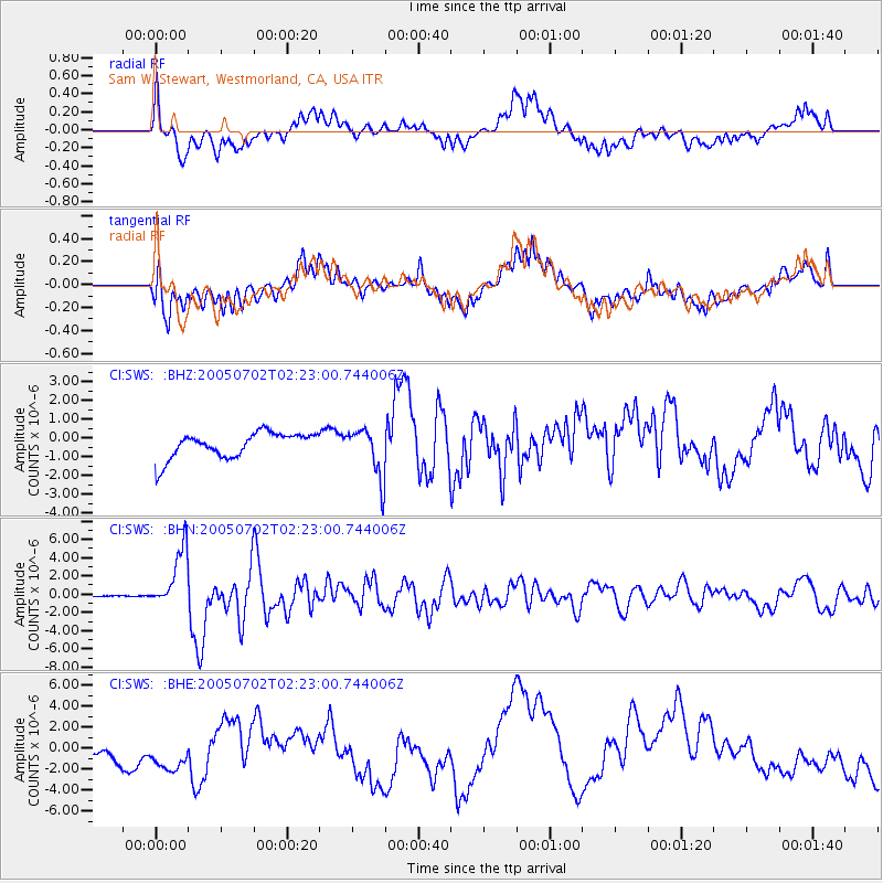
SWS Sam W. Stewart, Westmorland, CA, USA - Earthquake Result Viewer
*The percent match for this event was below the threshold and hence no stack was calculated.
| Earthquake location: |
Near Coast Of Nicaragua |
| Earthquake latitude/longitude: |
11.2/-86.2 |
| Earthquake time(UTC): |
2005/07/02 (183) 02:16:43 GMT |
| Earthquake Depth: |
27 km |
| Earthquake Magnitude: |
5.6 MB, 6.4 MS, 6.6 MW, 6.6 MW |
| Earthquake Catalog/Contributor: |
WHDF/NEIC |
|
| Network: |
CI Caltech Regional Seismic Network |
| Station: |
SWS Sam W. Stewart, Westmorland, CA, USA |
| Lat/Lon: |
32.94 N/115.80 W |
| Elevation: |
140 m |
|
| Distance: |
34.7 deg |
| Az: |
313.126 deg |
| Baz: |
121.625 deg |
| Ray Param: |
$rayparam |
*The percent match for this event was below the threshold and hence was not used in the summary stack. |
|
| Radial Match: |
60.26955 % |
| Radial Bump: |
400 |
| Transverse Match: |
56.094177 % |
| Transverse Bump: |
400 |
| SOD ConfigId: |
3128 |
| Insert Time: |
2010-03-05 20:35:35.764 +0000 |
| GWidth: |
2.5 |
| Max Bumps: |
400 |
| Tol: |
0.001 |
|
Signal To Noise
| Channel | StoN | STA | LTA |
| CI:SWS: :BHN:20050702T02:23:00.744006Z | 38.451965 | 3.2284602E-6 | 8.396086E-8 |
| CI:SWS: :BHE:20050702T02:23:00.744006Z | 1.1365728 | 2.3826867E-6 | 2.0963782E-6 |
| CI:SWS: :BHZ:20050702T02:23:00.744006Z | 1.9512589 | 1.3126255E-6 | 6.72707E-7 |
| Arrivals |
| Ps | |
| PpPs | |
| PsPs/PpSs | |


