You are here: Home > Network List > G - GEOSCOPE Stations List
> Station MBO M'Bour, Senegal > Earthquake Result Viewer
MBO M'Bour, Senegal - Earthquake Result Viewer
| Earthquake location: |
Hindu Kush Region, Afghanistan |
| Earthquake latitude/longitude: |
36.4/70.7 |
| Earthquake time(UTC): |
2015/10/26 (299) 09:09:32 GMT |
| Earthquake Depth: |
212 km |
| Earthquake Magnitude: |
7.5 MWW, 7.5 MWB |
| Earthquake Catalog/Contributor: |
NEIC PDE/NEIC COMCAT |
|
| Network: |
G GEOSCOPE |
| Station: |
MBO M'Bour, Senegal |
| Lat/Lon: |
14.39 N/16.95 W |
| Elevation: |
3.0 m |
|
| Distance: |
79.8 deg |
| Az: |
280.295 deg |
| Baz: |
54.96 deg |
| Ray Param: |
0.048208144 |
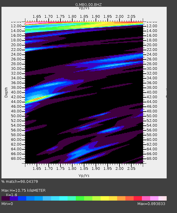
| Estimated Moho Depth: |
10.75 km |
| Estimated Crust Vp/Vs: |
1.60 |
| Assumed Crust Vp: |
5.55 km/s |
| Estimated Crust Vs: |
3.469 km/s |
| Estimated Crust Poisson's Ratio: |
0.18 |
|
| Radial Match: |
98.04379 % |
| Radial Bump: |
320 |
| Transverse Match: |
96.07343 % |
| Transverse Bump: |
400 |
| SOD ConfigId: |
1259291 |
| Insert Time: |
2015-11-09 09:52:16.715 +0000 |
| GWidth: |
2.5 |
| Max Bumps: |
400 |
| Tol: |
0.001 |
|
Signal To Noise
| Channel | StoN | STA | LTA |
| G:MBO:00:BHZ:20151026T09:20:45.900015Z | 3.0703053 | 1.683404E-6 | 5.482855E-7 |
| G:MBO:00:BHN:20151026T09:20:45.900015Z | 1.1936264 | 5.6544906E-7 | 4.7372362E-7 |
| G:MBO:00:BHE:20151026T09:20:45.900015Z | 1.1372144 | 5.161582E-7 | 4.5387938E-7 |
| Arrivals |
| Ps | 1.2 SECOND |
| PpPs | 4.9 SECOND |
| PsPs/PpSs | 6.1 SECOND |


