You are here: Home > Network List > CI - Caltech Regional Seismic Network Stations List
> Station SWS Sam W. Stewart, Westmorland, CA, USA > Earthquake Result Viewer
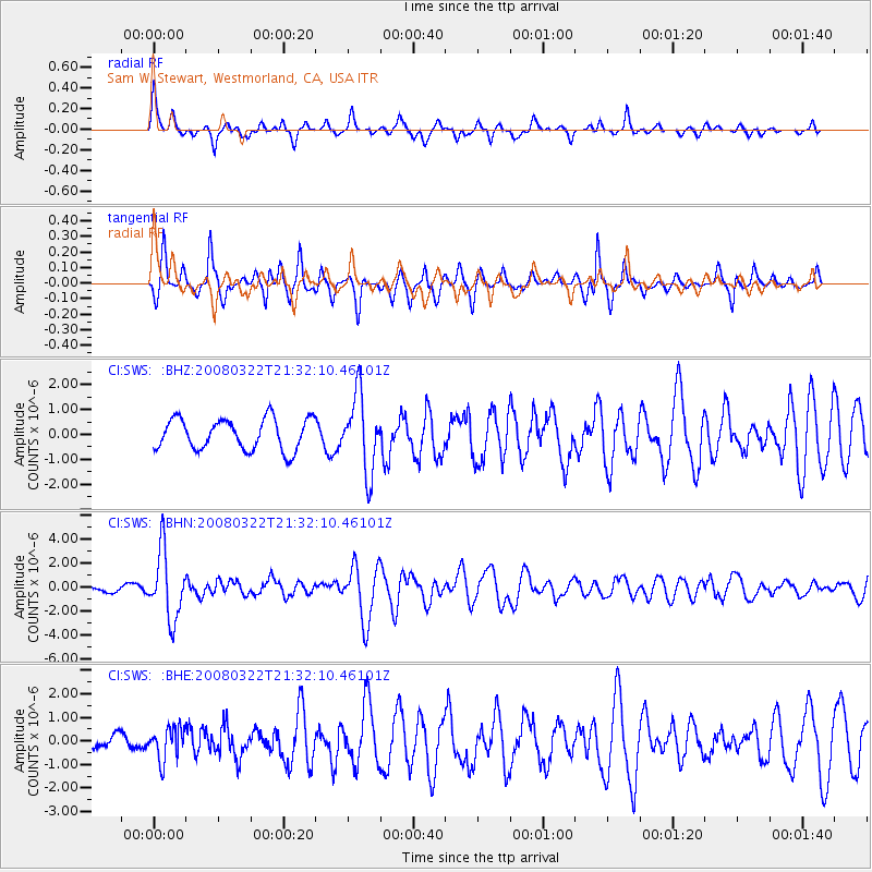
SWS Sam W. Stewart, Westmorland, CA, USA - Earthquake Result Viewer
*The percent match for this event was below the threshold and hence no stack was calculated.
| Earthquake location: |
Andreanof Islands, Aleutian Is. |
| Earthquake latitude/longitude: |
52.2/-178.7 |
| Earthquake time(UTC): |
2008/03/22 (082) 21:24:11 GMT |
| Earthquake Depth: |
132 km |
| Earthquake Magnitude: |
5.8 MB, 6.2 MW, 6.1 MW |
| Earthquake Catalog/Contributor: |
WHDF/NEIC |
|
| Network: |
CI Caltech Regional Seismic Network |
| Station: |
SWS Sam W. Stewart, Westmorland, CA, USA |
| Lat/Lon: |
32.94 N/115.80 W |
| Elevation: |
140 m |
|
| Distance: |
48.5 deg |
| Az: |
87.578 deg |
| Baz: |
312.973 deg |
| Ray Param: |
$rayparam |
*The percent match for this event was below the threshold and hence was not used in the summary stack. |
|
| Radial Match: |
70.89305 % |
| Radial Bump: |
315 |
| Transverse Match: |
67.86341 % |
| Transverse Bump: |
301 |
| SOD ConfigId: |
2504 |
| Insert Time: |
2010-03-05 20:35:38.952 +0000 |
| GWidth: |
2.5 |
| Max Bumps: |
400 |
| Tol: |
0.001 |
|
Signal To Noise
| Channel | StoN | STA | LTA |
| CI:SWS: :BHN:20080322T21:32:10.46101Z | 8.721911 | 2.8002457E-6 | 3.210587E-7 |
| CI:SWS: :BHE:20080322T21:32:10.46101Z | 1.3069782 | 7.0242606E-7 | 5.374428E-7 |
| CI:SWS: :BHZ:20080322T21:32:10.46101Z | 2.4436696 | 1.5220267E-6 | 6.228447E-7 |
| Arrivals |
| Ps | |
| PpPs | |
| PsPs/PpSs | |


