You are here: Home > Network List > TA - USArray Transportable Network (new EarthScope stations) Stations List
> Station M31M Drury Creek, Yukon, CA > Earthquake Result Viewer
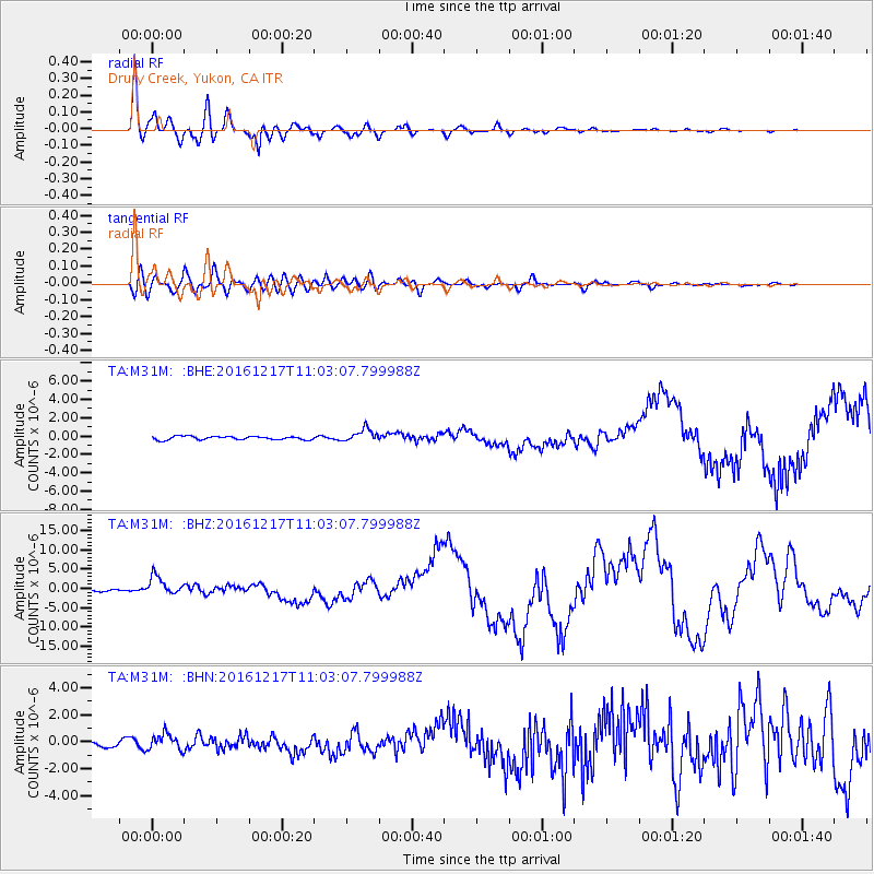
M31M Drury Creek, Yukon, CA - Earthquake Result Viewer
*The percent match for this event was below the threshold and hence no stack was calculated.
| Earthquake location: |
New Ireland Region, P.N.G. |
| Earthquake latitude/longitude: |
-4.5/153.6 |
| Earthquake time(UTC): |
2016/12/17 (352) 10:51:11 GMT |
| Earthquake Depth: |
73 km |
| Earthquake Magnitude: |
8.0 Mi |
| Earthquake Catalog/Contributor: |
NEIC PDE/pt |
|
| Network: |
TA USArray Transportable Network (new EarthScope stations) |
| Station: |
M31M Drury Creek, Yukon, CA |
| Lat/Lon: |
62.20 N/134.39 W |
| Elevation: |
639 m |
|
| Distance: |
85.7 deg |
| Az: |
26.566 deg |
| Baz: |
252.009 deg |
| Ray Param: |
$rayparam |
*The percent match for this event was below the threshold and hence was not used in the summary stack. |
|
| Radial Match: |
97.65042 % |
| Radial Bump: |
400 |
| Transverse Match: |
80.45466 % |
| Transverse Bump: |
400 |
| SOD ConfigId: |
11737051 |
| Insert Time: |
2019-04-26 08:15:44.447 +0000 |
| GWidth: |
2.5 |
| Max Bumps: |
400 |
| Tol: |
0.001 |
|
Signal To Noise
| Channel | StoN | STA | LTA |
| TA:M31M: :BHZ:20161217T11:03:07.799988Z | 7.17291 | 2.386825E-6 | 3.3275546E-7 |
| TA:M31M: :BHN:20161217T11:03:07.799988Z | 2.2050025 | 6.152147E-7 | 2.790086E-7 |
| TA:M31M: :BHE:20161217T11:03:07.799988Z | 4.0989714 | 6.907826E-7 | 1.6852584E-7 |
| Arrivals |
| Ps | |
| PpPs | |
| PsPs/PpSs | |


