You are here: Home > Network List > CI - Caltech Regional Seismic Network Stations List
> Station SWS Sam W. Stewart, Westmorland, CA, USA > Earthquake Result Viewer
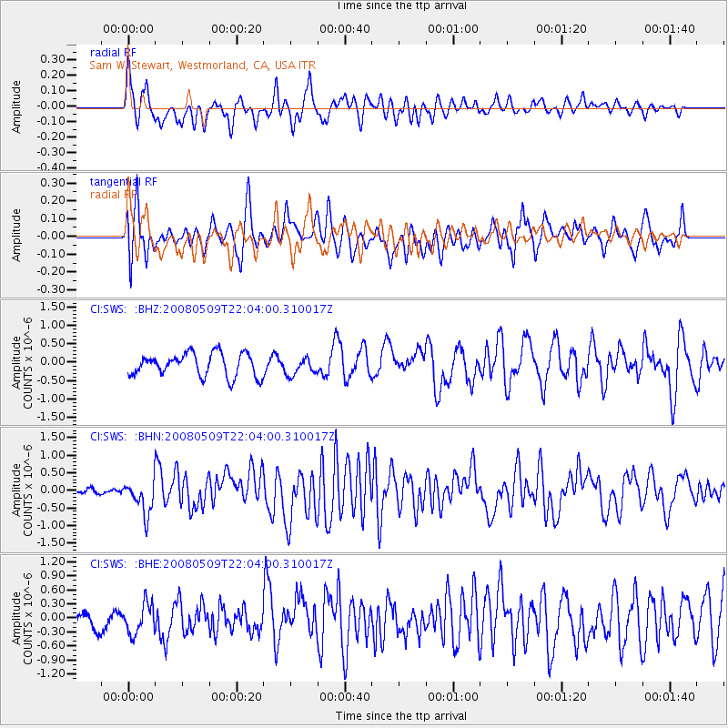
SWS Sam W. Stewart, Westmorland, CA, USA - Earthquake Result Viewer
*The percent match for this event was below the threshold and hence no stack was calculated.
| Earthquake location: |
South Of Mariana Islands |
| Earthquake latitude/longitude: |
12.5/143.2 |
| Earthquake time(UTC): |
2008/05/09 (130) 21:51:29 GMT |
| Earthquake Depth: |
76 km |
| Earthquake Magnitude: |
6.1 MB, 6.7 MW, 6.7 MW |
| Earthquake Catalog/Contributor: |
WHDF/NEIC |
|
| Network: |
CI Caltech Regional Seismic Network |
| Station: |
SWS Sam W. Stewart, Westmorland, CA, USA |
| Lat/Lon: |
32.94 N/115.80 W |
| Elevation: |
140 m |
|
| Distance: |
92.3 deg |
| Az: |
55.696 deg |
| Baz: |
286.401 deg |
| Ray Param: |
$rayparam |
*The percent match for this event was below the threshold and hence was not used in the summary stack. |
|
| Radial Match: |
48.39813 % |
| Radial Bump: |
339 |
| Transverse Match: |
63.36261 % |
| Transverse Bump: |
360 |
| SOD ConfigId: |
2504 |
| Insert Time: |
2010-03-05 20:35:41.028 +0000 |
| GWidth: |
2.5 |
| Max Bumps: |
400 |
| Tol: |
0.001 |
|
Signal To Noise
| Channel | StoN | STA | LTA |
| CI:SWS: :BHN:20080509T22:04:00.310017Z | 3.8892329 | 4.89193E-7 | 1.2578136E-7 |
| CI:SWS: :BHE:20080509T22:04:00.310017Z | 1.4503595 | 3.2677974E-7 | 2.2530949E-7 |
| CI:SWS: :BHZ:20080509T22:04:00.310017Z | 0.76405025 | 2.356796E-7 | 3.0846087E-7 |
| Arrivals |
| Ps | |
| PpPs | |
| PsPs/PpSs | |


