You are here: Home > Network List > UW - Pacific Northwest Regional Seismic Network Stations List
> Station MRBL Marblemount, WA, USA > Earthquake Result Viewer
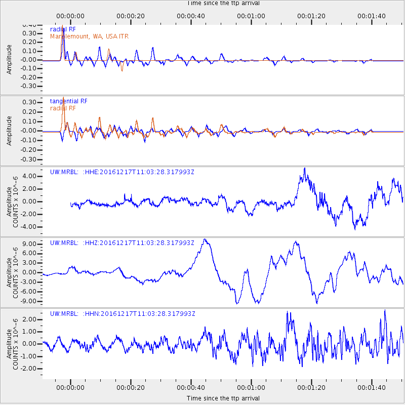
MRBL Marblemount, WA, USA - Earthquake Result Viewer
*The percent match for this event was below the threshold and hence no stack was calculated.
| Earthquake location: |
New Ireland Region, P.N.G. |
| Earthquake latitude/longitude: |
-4.5/153.6 |
| Earthquake time(UTC): |
2016/12/17 (352) 10:51:11 GMT |
| Earthquake Depth: |
73 km |
| Earthquake Magnitude: |
8.0 Mi |
| Earthquake Catalog/Contributor: |
NEIC PDE/pt |
|
| Network: |
UW Pacific Northwest Regional Seismic Network |
| Station: |
MRBL Marblemount, WA, USA |
| Lat/Lon: |
48.52 N/121.48 W |
| Elevation: |
75 m |
|
| Distance: |
90.0 deg |
| Az: |
41.474 deg |
| Baz: |
263.268 deg |
| Ray Param: |
$rayparam |
*The percent match for this event was below the threshold and hence was not used in the summary stack. |
|
| Radial Match: |
84.620224 % |
| Radial Bump: |
400 |
| Transverse Match: |
64.66549 % |
| Transverse Bump: |
400 |
| SOD ConfigId: |
11737051 |
| Insert Time: |
2019-04-26 08:17:09.471 +0000 |
| GWidth: |
2.5 |
| Max Bumps: |
400 |
| Tol: |
0.001 |
|
Signal To Noise
| Channel | StoN | STA | LTA |
| UW:MRBL: :HHZ:20161217T11:03:28.317993Z | 4.927286 | 1.294108E-6 | 2.6264112E-7 |
| UW:MRBL: :HHN:20161217T11:03:28.317993Z | 0.69789076 | 2.9686274E-7 | 4.2537135E-7 |
| UW:MRBL: :HHE:20161217T11:03:28.317993Z | 1.6144272 | 6.056179E-7 | 3.7512865E-7 |
| Arrivals |
| Ps | |
| PpPs | |
| PsPs/PpSs | |


