You are here: Home > Network List > IU - Global Seismograph Network (GSN - IRIS/USGS) Stations List
> Station CTAO Charters Towers, Australia > Earthquake Result Viewer
CTAO Charters Towers, Australia - Earthquake Result Viewer
| Earthquake location: |
Hindu Kush Region, Afghanistan |
| Earthquake latitude/longitude: |
36.4/70.7 |
| Earthquake time(UTC): |
2015/10/26 (299) 09:09:32 GMT |
| Earthquake Depth: |
212 km |
| Earthquake Magnitude: |
7.5 MWW, 7.5 MWB |
| Earthquake Catalog/Contributor: |
NEIC PDE/NEIC COMCAT |
|
| Network: |
IU Global Seismograph Network (GSN - IRIS/USGS) |
| Station: |
CTAO Charters Towers, Australia |
| Lat/Lon: |
20.09 S/146.25 E |
| Elevation: |
357 m |
|
| Distance: |
90.7 deg |
| Az: |
114.468 deg |
| Baz: |
308.658 deg |
| Ray Param: |
0.04160601 |
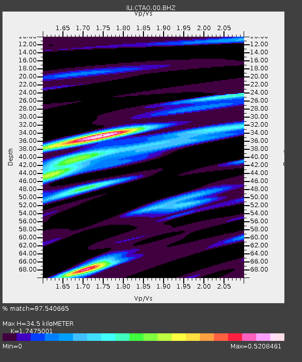
| Estimated Moho Depth: |
34.5 km |
| Estimated Crust Vp/Vs: |
1.75 |
| Assumed Crust Vp: |
6.522 km/s |
| Estimated Crust Vs: |
3.732 km/s |
| Estimated Crust Poisson's Ratio: |
0.26 |
|
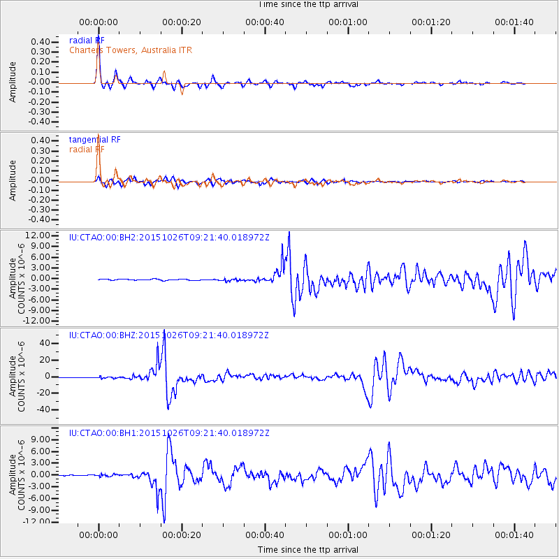
| Radial Match: |
97.540665 % |
| Radial Bump: |
235 |
| Transverse Match: |
93.99048 % |
| Transverse Bump: |
352 |
| SOD ConfigId: |
1259291 |
| Insert Time: |
2015-11-09 09:53:30.018 +0000 |
| GWidth: |
2.5 |
| Max Bumps: |
400 |
| Tol: |
0.001 |
|
Signal To Noise
| Channel | StoN | STA | LTA |
| IU:CTAO:00:BHZ:20151026T09:21:40.018972Z | 5.5825505 | 1.012394E-6 | 1.8134973E-7 |
| IU:CTAO:00:BH1:20151026T09:21:40.018972Z | 1.9063497 | 2.842662E-7 | 1.4911545E-7 |
| IU:CTAO:00:BH2:20151026T09:21:40.018972Z | 1.9229337 | 3.0832211E-7 | 1.6033944E-7 |
| Arrivals |
| Ps | 4.0 SECOND |
| PpPs | 14 SECOND |
| PsPs/PpSs | 18 SECOND |


