You are here: Home > Network List > YT07 - POLENET Stations List
> Station WAIS WAIS > Earthquake Result Viewer
WAIS WAIS - Earthquake Result Viewer
| Earthquake location: |
New Ireland Region, P.N.G. |
| Earthquake latitude/longitude: |
-4.5/153.6 |
| Earthquake time(UTC): |
2016/12/17 (352) 10:51:11 GMT |
| Earthquake Depth: |
73 km |
| Earthquake Magnitude: |
8.0 Mi |
| Earthquake Catalog/Contributor: |
NEIC PDE/pt |
|
| Network: |
YT POLENET |
| Station: |
WAIS WAIS |
| Lat/Lon: |
79.42 S/111.78 W |
| Elevation: |
1800 m |
|
| Distance: |
86.5 deg |
| Az: |
169.364 deg |
| Baz: |
264.615 deg |
| Ray Param: |
0.043871023 |
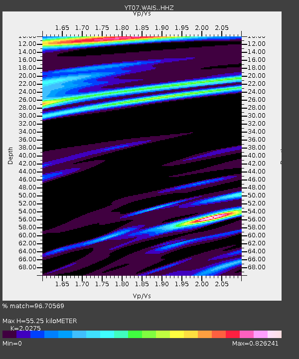
| Estimated Moho Depth: |
55.25 km |
| Estimated Crust Vp/Vs: |
2.03 |
| Assumed Crust Vp: |
5.833 km/s |
| Estimated Crust Vs: |
2.877 km/s |
| Estimated Crust Poisson's Ratio: |
0.34 |
|
| Radial Match: |
96.70569 % |
| Radial Bump: |
296 |
| Transverse Match: |
94.13916 % |
| Transverse Bump: |
400 |
| SOD ConfigId: |
11737051 |
| Insert Time: |
2019-04-26 08:18:19.076 +0000 |
| GWidth: |
2.5 |
| Max Bumps: |
400 |
| Tol: |
0.001 |
|

Signal To Noise
| Channel | StoN | STA | LTA |
| YT:WAIS: :HHZ:20161217T11:03:11.51001Z | 25.835943 | 7.173198E-6 | 2.7764412E-7 |
| YT:WAIS: :HHN:20161217T11:03:11.51001Z | 6.02119 | 6.388672E-7 | 1.0610315E-7 |
| YT:WAIS: :HHE:20161217T11:03:11.51001Z | 11.07752 | 2.0441666E-6 | 1.8453287E-7 |
| Arrivals |
| Ps | 9.9 SECOND |
| PpPs | 28 SECOND |
| PsPs/PpSs | 38 SECOND |


