You are here: Home > Network List > CI - Caltech Regional Seismic Network Stations List
> Station SWS Sam W. Stewart, Westmorland, CA, USA > Earthquake Result Viewer
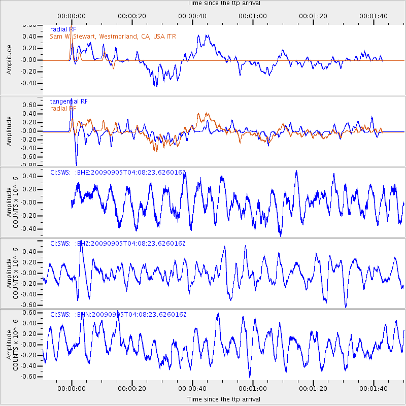
SWS Sam W. Stewart, Westmorland, CA, USA - Earthquake Result Viewer
*The percent match for this event was below the threshold and hence no stack was calculated.
| Earthquake location: |
Southern Peru |
| Earthquake latitude/longitude: |
-15.1/-70.2 |
| Earthquake time(UTC): |
2009/09/05 (248) 03:58:39 GMT |
| Earthquake Depth: |
210 km |
| Earthquake Magnitude: |
5.8 MW, 5.2 MB, 5.8 MW |
| Earthquake Catalog/Contributor: |
WHDF/NEIC |
|
| Network: |
CI Caltech Regional Seismic Network |
| Station: |
SWS Sam W. Stewart, Westmorland, CA, USA |
| Lat/Lon: |
32.94 N/115.80 W |
| Elevation: |
140 m |
|
| Distance: |
64.6 deg |
| Az: |
318.369 deg |
| Baz: |
130.269 deg |
| Ray Param: |
$rayparam |
*The percent match for this event was below the threshold and hence was not used in the summary stack. |
|
| Radial Match: |
28.75758 % |
| Radial Bump: |
400 |
| Transverse Match: |
59.067387 % |
| Transverse Bump: |
400 |
| SOD ConfigId: |
2622 |
| Insert Time: |
2010-03-05 20:36:30.287 +0000 |
| GWidth: |
2.5 |
| Max Bumps: |
400 |
| Tol: |
0.001 |
|
Signal To Noise
| Channel | StoN | STA | LTA |
| CI:SWS: :BHZ:20090905T04:08:23.626016Z | 2.6560943 | 2.780586E-7 | 1.0468702E-7 |
| CI:SWS: :BHN:20090905T04:08:23.626016Z | 1.3947359 | 2.7515523E-7 | 1.9728124E-7 |
| CI:SWS: :BHE:20090905T04:08:23.626016Z | 1.0093374 | 1.7420334E-7 | 1.7259178E-7 |
| Arrivals |
| Ps | |
| PpPs | |
| PsPs/PpSs | |


