You are here: Home > Network List > CI - Caltech Regional Seismic Network Stations List
> Station MPM Manuel Prospect Mine, California, USA > Earthquake Result Viewer
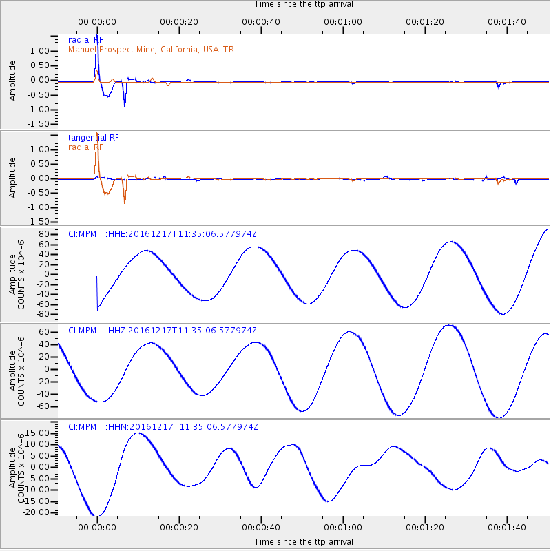
MPM Manuel Prospect Mine, California, USA - Earthquake Result Viewer
| Earthquake location: |
New Ireland Region, P.N.G. |
| Earthquake latitude/longitude: |
-4.4/153.5 |
| Earthquake time(UTC): |
2016/12/17 (352) 11:22:39 GMT |
| Earthquake Depth: |
83 km |
| Earthquake Magnitude: |
5.6 mb |
| Earthquake Catalog/Contributor: |
NEIC PDE/us |
|
| Network: |
CI Caltech Regional Seismic Network |
| Station: |
MPM Manuel Prospect Mine, California, USA |
| Lat/Lon: |
36.06 N/117.49 W |
| Elevation: |
185 m |
|
| Distance: |
91.7 deg |
| Az: |
54.149 deg |
| Baz: |
265.834 deg |
| Ray Param: |
0.041530896 |
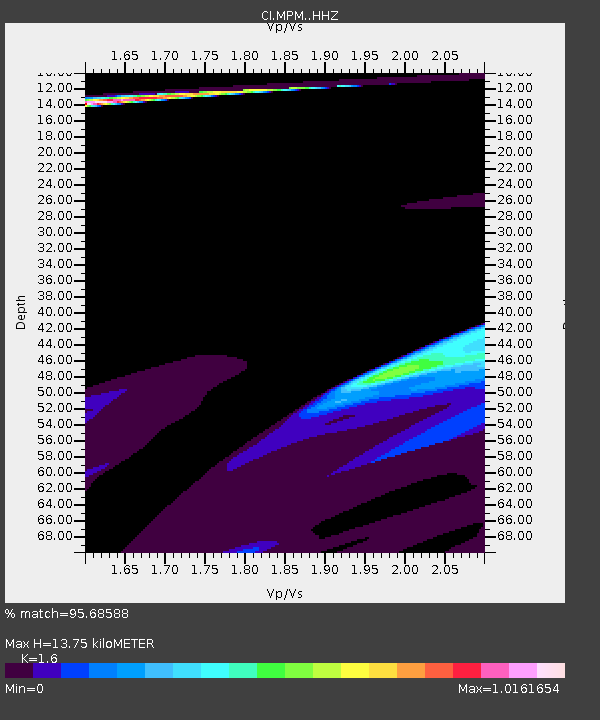
| Estimated Moho Depth: |
13.75 km |
| Estimated Crust Vp/Vs: |
1.60 |
| Assumed Crust Vp: |
6.279 km/s |
| Estimated Crust Vs: |
3.924 km/s |
| Estimated Crust Poisson's Ratio: |
0.18 |
|
| Radial Match: |
95.68588 % |
| Radial Bump: |
329 |
| Transverse Match: |
54.353523 % |
| Transverse Bump: |
400 |
| SOD ConfigId: |
11737051 |
| Insert Time: |
2019-04-26 08:21:10.002 +0000 |
| GWidth: |
2.5 |
| Max Bumps: |
400 |
| Tol: |
0.001 |
|
Signal To Noise
| Channel | StoN | STA | LTA |
| CI:MPM: :HHZ:20161217T11:35:06.577974Z | 0.8521387 | 4.3451204E-5 | 5.0990762E-5 |
| CI:MPM: :HHN:20161217T11:35:06.577974Z | 2.4822686 | 1.918771E-5 | 7.729908E-6 |
| CI:MPM: :HHE:20161217T11:35:06.577974Z | 0.69249964 | 2.4018544E-5 | 3.4683835E-5 |
| Arrivals |
| Ps | 1.3 SECOND |
| PpPs | 5.6 SECOND |
| PsPs/PpSs | 6.9 SECOND |


