You are here: Home > Network List > PF - Volcanologic Network of Piton de Fournaise-OVPF Stations List
> Station BON Bory Nord > Earthquake Result Viewer
BON Bory Nord - Earthquake Result Viewer
| Earthquake location: |
New Ireland Region, P.N.G. |
| Earthquake latitude/longitude: |
-4.4/153.5 |
| Earthquake time(UTC): |
2016/12/17 (352) 11:22:39 GMT |
| Earthquake Depth: |
83 km |
| Earthquake Magnitude: |
5.6 mb |
| Earthquake Catalog/Contributor: |
NEIC PDE/us |
|
| Network: |
PF Volcanologic Network of Piton de Fournaise-OVPF |
| Station: |
BON Bory Nord |
| Lat/Lon: |
21.24 S/55.71 E |
| Elevation: |
2552 m |
|
| Distance: |
95.7 deg |
| Az: |
248.243 deg |
| Baz: |
96.951 deg |
| Ray Param: |
0.040658675 |
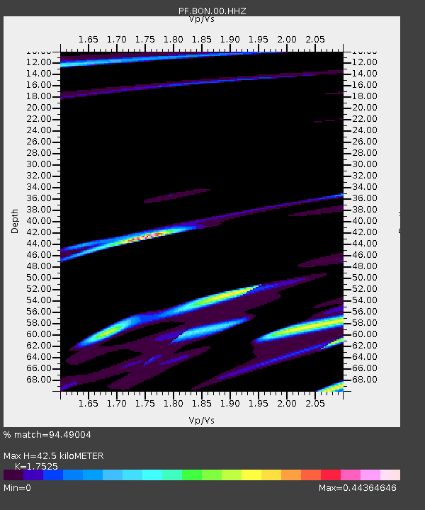
| Estimated Moho Depth: |
42.5 km |
| Estimated Crust Vp/Vs: |
1.75 |
| Assumed Crust Vp: |
4.73 km/s |
| Estimated Crust Vs: |
2.699 km/s |
| Estimated Crust Poisson's Ratio: |
0.26 |
|
| Radial Match: |
94.49004 % |
| Radial Bump: |
400 |
| Transverse Match: |
45.705193 % |
| Transverse Bump: |
400 |
| SOD ConfigId: |
11737051 |
| Insert Time: |
2019-04-26 08:22:35.437 +0000 |
| GWidth: |
2.5 |
| Max Bumps: |
400 |
| Tol: |
0.001 |
|
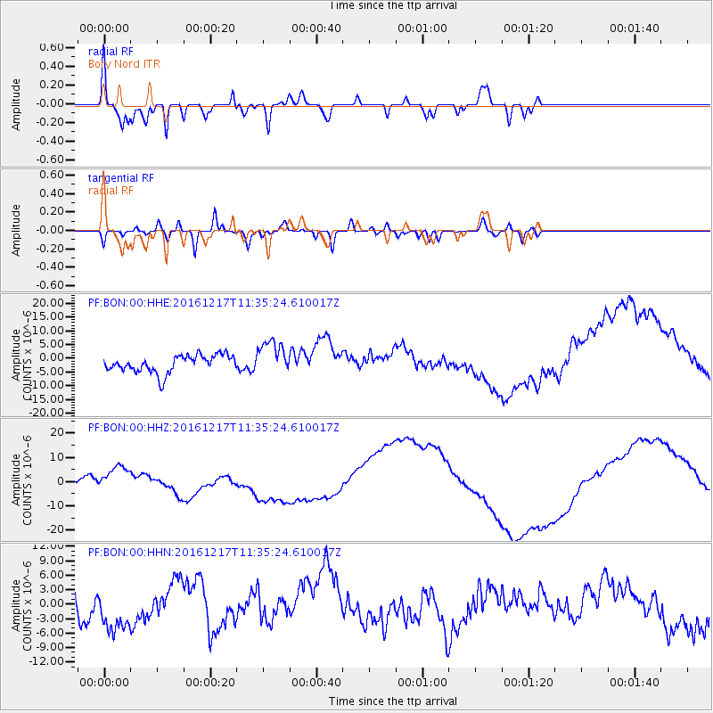
Signal To Noise
| Channel | StoN | STA | LTA |
| PF:BON:00:HHZ:20161217T11:35:24.610017Z | 2.889921 | 5.318782E-6 | 1.8404593E-6 |
| PF:BON:00:HHN:20161217T11:35:24.610017Z | 1.9505908 | 5.548793E-6 | 2.8446732E-6 |
| PF:BON:00:HHE:20161217T11:35:24.610017Z | 1.9885087 | 6.284778E-6 | 3.1605484E-6 |
| Arrivals |
| Ps | 6.8 SECOND |
| PpPs | 24 SECOND |
| PsPs/PpSs | 31 SECOND |


