You are here: Home > Network List > UW - Pacific Northwest Regional Seismic Network Stations List
> Station MRBL Marblemount, WA, USA > Earthquake Result Viewer
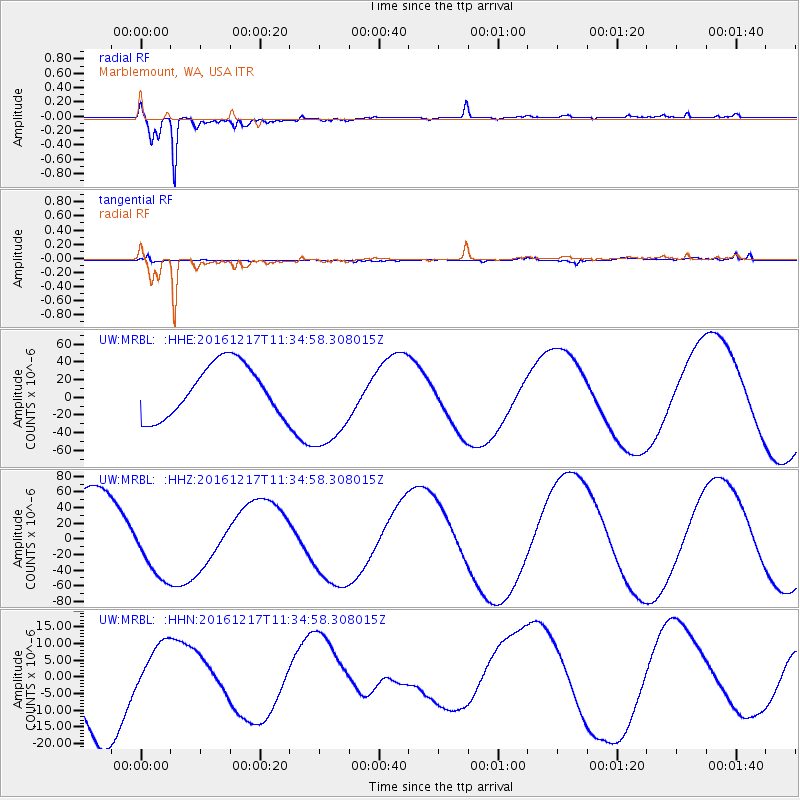
MRBL Marblemount, WA, USA - Earthquake Result Viewer
*The percent match for this event was below the threshold and hence no stack was calculated.
| Earthquake location: |
New Ireland Region, P.N.G. |
| Earthquake latitude/longitude: |
-4.4/153.5 |
| Earthquake time(UTC): |
2016/12/17 (352) 11:22:39 GMT |
| Earthquake Depth: |
83 km |
| Earthquake Magnitude: |
5.6 mb |
| Earthquake Catalog/Contributor: |
NEIC PDE/us |
|
| Network: |
UW Pacific Northwest Regional Seismic Network |
| Station: |
MRBL Marblemount, WA, USA |
| Lat/Lon: |
48.52 N/121.48 W |
| Elevation: |
75 m |
|
| Distance: |
90.0 deg |
| Az: |
41.477 deg |
| Baz: |
263.327 deg |
| Ray Param: |
$rayparam |
*The percent match for this event was below the threshold and hence was not used in the summary stack. |
|
| Radial Match: |
94.70813 % |
| Radial Bump: |
400 |
| Transverse Match: |
60.719734 % |
| Transverse Bump: |
400 |
| SOD ConfigId: |
11737051 |
| Insert Time: |
2019-04-26 08:23:49.533 +0000 |
| GWidth: |
2.5 |
| Max Bumps: |
400 |
| Tol: |
0.001 |
|
Signal To Noise
| Channel | StoN | STA | LTA |
| UW:MRBL: :HHZ:20161217T11:34:58.308015Z | 1.0433125 | 4.3195672E-5 | 4.140243E-5 |
| UW:MRBL: :HHN:20161217T11:34:58.308015Z | 0.6018387 | 7.955986E-6 | 1.32194655E-5 |
| UW:MRBL: :HHE:20161217T11:34:58.308015Z | 1.8803966 | 5.5174707E-5 | 2.9342058E-5 |
| Arrivals |
| Ps | |
| PpPs | |
| PsPs/PpSs | |


