You are here: Home > Network List > CI - Caltech Regional Seismic Network Stations List
> Station SWS Sam W. Stewart, Westmorland, CA, USA > Earthquake Result Viewer
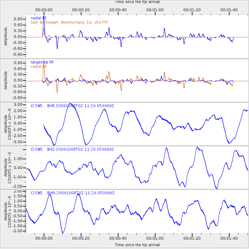
SWS Sam W. Stewart, Westmorland, CA, USA - Earthquake Result Viewer
*The percent match for this event was below the threshold and hence no stack was calculated.
| Earthquake location: |
Santa Cruz Islands |
| Earthquake latitude/longitude: |
-11.9/166.0 |
| Earthquake time(UTC): |
2009/10/08 (281) 01:59:19 GMT |
| Earthquake Depth: |
35 km |
| Earthquake Magnitude: |
5.9 MB |
| Earthquake Catalog/Contributor: |
WHDF/NEIC |
|
| Network: |
CI Caltech Regional Seismic Network |
| Station: |
SWS Sam W. Stewart, Westmorland, CA, USA |
| Lat/Lon: |
32.94 N/115.80 W |
| Elevation: |
140 m |
|
| Distance: |
86.7 deg |
| Az: |
55.547 deg |
| Baz: |
253.702 deg |
| Ray Param: |
$rayparam |
*The percent match for this event was below the threshold and hence was not used in the summary stack. |
|
| Radial Match: |
65.71833 % |
| Radial Bump: |
246 |
| Transverse Match: |
26.936144 % |
| Transverse Bump: |
397 |
| SOD ConfigId: |
2622 |
| Insert Time: |
2010-03-05 20:36:43.261 +0000 |
| GWidth: |
2.5 |
| Max Bumps: |
400 |
| Tol: |
0.001 |
|
Signal To Noise
| Channel | StoN | STA | LTA |
| CI:SWS: :BHZ:20091008T02:11:29.050999Z | 0.730965 | 5.8244643E-7 | 7.968185E-7 |
| CI:SWS: :BHN:20091008T02:11:29.050999Z | 1.4347236 | 9.558272E-7 | 6.662099E-7 |
| CI:SWS: :BHE:20091008T02:11:29.050999Z | 0.9480531 | 2.0905727E-6 | 2.2051217E-6 |
| Arrivals |
| Ps | |
| PpPs | |
| PsPs/PpSs | |


