You are here: Home > Network List > CI - Caltech Regional Seismic Network Stations List
> Station SWS Sam W. Stewart, Westmorland, CA, USA > Earthquake Result Viewer
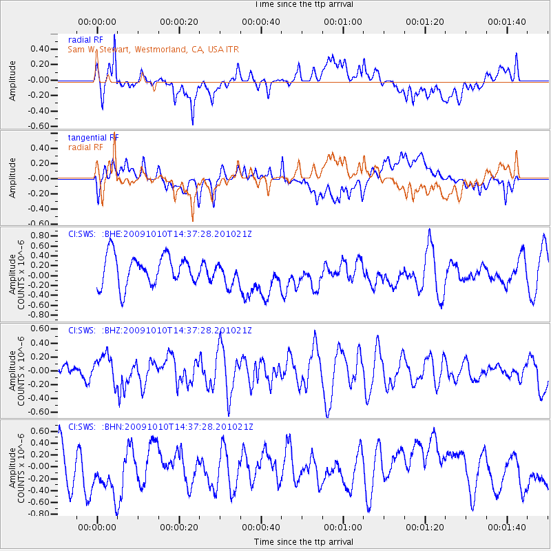
SWS Sam W. Stewart, Westmorland, CA, USA - Earthquake Result Viewer
*The percent match for this event was below the threshold and hence no stack was calculated.
| Earthquake location: |
Vanuatu Islands |
| Earthquake latitude/longitude: |
-14.1/166.7 |
| Earthquake time(UTC): |
2009/10/10 (283) 14:25:15 GMT |
| Earthquake Depth: |
35 km |
| Earthquake Magnitude: |
5.6 MB, 5.7 MS, 5.8 MW, 5.8 MW |
| Earthquake Catalog/Contributor: |
WHDF/NEIC |
|
| Network: |
CI Caltech Regional Seismic Network |
| Station: |
SWS Sam W. Stewart, Westmorland, CA, USA |
| Lat/Lon: |
32.94 N/115.80 W |
| Elevation: |
140 m |
|
| Distance: |
87.4 deg |
| Az: |
55.27 deg |
| Baz: |
251.479 deg |
| Ray Param: |
$rayparam |
*The percent match for this event was below the threshold and hence was not used in the summary stack. |
|
| Radial Match: |
48.729397 % |
| Radial Bump: |
400 |
| Transverse Match: |
39.70367 % |
| Transverse Bump: |
400 |
| SOD ConfigId: |
2622 |
| Insert Time: |
2010-03-05 20:36:45.562 +0000 |
| GWidth: |
2.5 |
| Max Bumps: |
400 |
| Tol: |
0.001 |
|
Signal To Noise
| Channel | StoN | STA | LTA |
| CI:SWS: :BHZ:20091010T14:37:28.201021Z | 1.2379748 | 2.0523484E-7 | 1.6578274E-7 |
| CI:SWS: :BHN:20091010T14:37:28.201021Z | 1.6536835 | 5.0032406E-7 | 3.0255126E-7 |
| CI:SWS: :BHE:20091010T14:37:28.201021Z | 0.7952779 | 2.410627E-7 | 3.0311756E-7 |
| Arrivals |
| Ps | |
| PpPs | |
| PsPs/PpSs | |


