You are here: Home > Network List > CI - Caltech Regional Seismic Network Stations List
> Station SWS Sam W. Stewart, Westmorland, CA, USA > Earthquake Result Viewer
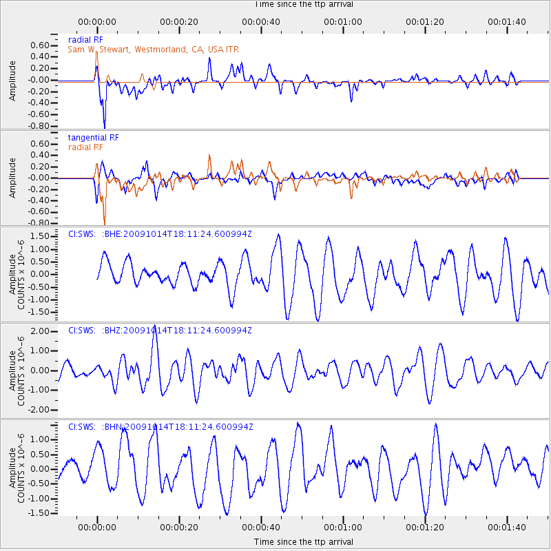
SWS Sam W. Stewart, Westmorland, CA, USA - Earthquake Result Viewer
*The percent match for this event was below the threshold and hence no stack was calculated.
| Earthquake location: |
Samoa Islands Region |
| Earthquake latitude/longitude: |
-14.9/-174.8 |
| Earthquake time(UTC): |
2009/10/14 (287) 18:00:21 GMT |
| Earthquake Depth: |
10 km |
| Earthquake Magnitude: |
5.7 MB, 6.0 MS, 6.3 MW, 6.2 MW |
| Earthquake Catalog/Contributor: |
WHDF/NEIC |
|
| Network: |
CI Caltech Regional Seismic Network |
| Station: |
SWS Sam W. Stewart, Westmorland, CA, USA |
| Lat/Lon: |
32.94 N/115.80 W |
| Elevation: |
140 m |
|
| Distance: |
73.7 deg |
| Az: |
48.68 deg |
| Baz: |
239.705 deg |
| Ray Param: |
$rayparam |
*The percent match for this event was below the threshold and hence was not used in the summary stack. |
|
| Radial Match: |
75.431404 % |
| Radial Bump: |
400 |
| Transverse Match: |
48.23214 % |
| Transverse Bump: |
400 |
| SOD ConfigId: |
2622 |
| Insert Time: |
2010-03-05 20:36:52.577 +0000 |
| GWidth: |
2.5 |
| Max Bumps: |
400 |
| Tol: |
0.001 |
|
Signal To Noise
| Channel | StoN | STA | LTA |
| CI:SWS: :BHZ:20091014T18:11:24.600994Z | 0.9909906 | 4.4030634E-7 | 4.443093E-7 |
| CI:SWS: :BHN:20091014T18:11:24.600994Z | 1.4913425 | 6.7166735E-7 | 4.5037766E-7 |
| CI:SWS: :BHE:20091014T18:11:24.600994Z | 1.7254602 | 6.5812503E-7 | 3.8142002E-7 |
| Arrivals |
| Ps | |
| PpPs | |
| PsPs/PpSs | |


