You are here: Home > Network List > TA - USArray Transportable Network (new EarthScope stations) Stations List
> Station D25K Kavik River, AK, USA > Earthquake Result Viewer
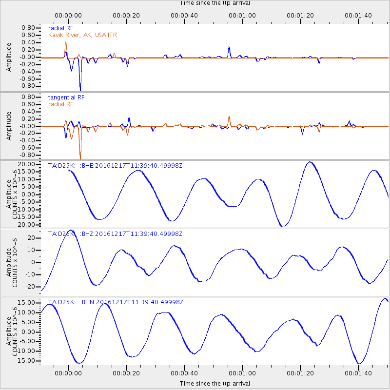
D25K Kavik River, AK, USA - Earthquake Result Viewer
*The percent match for this event was below the threshold and hence no stack was calculated.
| Earthquake location: |
New Ireland Region, P.N.G. |
| Earthquake latitude/longitude: |
-5.7/153.9 |
| Earthquake time(UTC): |
2016/12/17 (352) 11:27:41 GMT |
| Earthquake Depth: |
40 km |
| Earthquake Magnitude: |
6.0 mb |
| Earthquake Catalog/Contributor: |
NEIC PDE/us |
|
| Network: |
TA USArray Transportable Network (new EarthScope stations) |
| Station: |
D25K Kavik River, AK, USA |
| Lat/Lon: |
69.32 N/146.38 W |
| Elevation: |
770 m |
|
| Distance: |
85.1 deg |
| Az: |
17.926 deg |
| Baz: |
239.576 deg |
| Ray Param: |
$rayparam |
*The percent match for this event was below the threshold and hence was not used in the summary stack. |
|
| Radial Match: |
87.103264 % |
| Radial Bump: |
256 |
| Transverse Match: |
65.005745 % |
| Transverse Bump: |
400 |
| SOD ConfigId: |
11737051 |
| Insert Time: |
2019-04-26 08:28:39.027 +0000 |
| GWidth: |
2.5 |
| Max Bumps: |
400 |
| Tol: |
0.001 |
|
Signal To Noise
| Channel | StoN | STA | LTA |
| TA:D25K: :BHZ:20161217T11:39:40.49998Z | 1.658252 | 2.3970224E-5 | 1.4455115E-5 |
| TA:D25K: :BHN:20161217T11:39:40.49998Z | 1.3545285 | 1.3465698E-5 | 9.941245E-6 |
| TA:D25K: :BHE:20161217T11:39:40.49998Z | 0.98140126 | 1.1598252E-5 | 1.1818053E-5 |
| Arrivals |
| Ps | |
| PpPs | |
| PsPs/PpSs | |


