You are here: Home > Network List > TA - USArray Transportable Network (new EarthScope stations) Stations List
> Station TCOL CIGO, UAF Yankovich Road, Fairbanks, AK, USA > Earthquake Result Viewer
TCOL CIGO, UAF Yankovich Road, Fairbanks, AK, USA - Earthquake Result Viewer
| Earthquake location: |
New Ireland Region, P.N.G. |
| Earthquake latitude/longitude: |
-5.7/153.9 |
| Earthquake time(UTC): |
2016/12/17 (352) 11:27:41 GMT |
| Earthquake Depth: |
40 km |
| Earthquake Magnitude: |
6.0 mb |
| Earthquake Catalog/Contributor: |
NEIC PDE/us |
|
| Network: |
TA USArray Transportable Network (new EarthScope stations) |
| Station: |
TCOL CIGO, UAF Yankovich Road, Fairbanks, AK, USA |
| Lat/Lon: |
64.87 N/147.86 W |
| Elevation: |
178 m |
|
| Distance: |
82.3 deg |
| Az: |
21.483 deg |
| Baz: |
238.599 deg |
| Ray Param: |
0.046944927 |
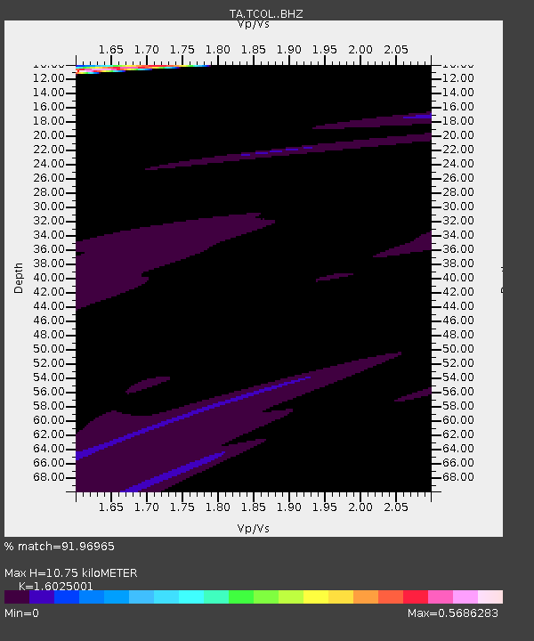
| Estimated Moho Depth: |
10.75 km |
| Estimated Crust Vp/Vs: |
1.60 |
| Assumed Crust Vp: |
6.566 km/s |
| Estimated Crust Vs: |
4.097 km/s |
| Estimated Crust Poisson's Ratio: |
0.18 |
|
| Radial Match: |
91.96965 % |
| Radial Bump: |
400 |
| Transverse Match: |
42.87843 % |
| Transverse Bump: |
329 |
| SOD ConfigId: |
11737051 |
| Insert Time: |
2019-04-26 08:29:07.582 +0000 |
| GWidth: |
2.5 |
| Max Bumps: |
400 |
| Tol: |
0.001 |
|

Signal To Noise
| Channel | StoN | STA | LTA |
| TA:TCOL: :BHZ:20161217T11:39:26.199993Z | 1.0299085 | 2.998847E-5 | 2.9117606E-5 |
| TA:TCOL: :BHN:20161217T11:39:26.199993Z | 1.3133402 | 1.9988885E-5 | 1.5219883E-5 |
| TA:TCOL: :BHE:20161217T11:39:26.199993Z | 1.6112336 | 3.70204E-5 | 2.2976432E-5 |
| Arrivals |
| Ps | 1.0 SECOND |
| PpPs | 4.1 SECOND |
| PsPs/PpSs | 5.1 SECOND |


