You are here: Home > Network List > UU - University of Utah Regional Network Stations List
> Station FORU South Mineral Mountains, UT, USA > Earthquake Result Viewer
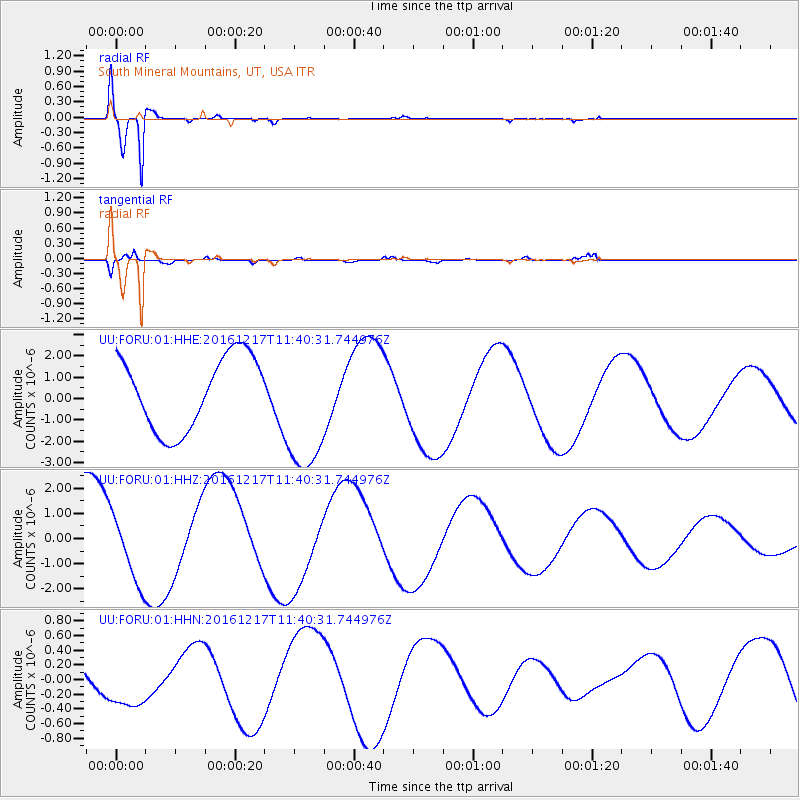
FORU South Mineral Mountains, UT, USA - Earthquake Result Viewer
*The percent match for this event was below the threshold and hence no stack was calculated.
| Earthquake location: |
New Ireland Region, P.N.G. |
| Earthquake latitude/longitude: |
-5.7/153.9 |
| Earthquake time(UTC): |
2016/12/17 (352) 11:27:41 GMT |
| Earthquake Depth: |
40 km |
| Earthquake Magnitude: |
6.0 mb |
| Earthquake Catalog/Contributor: |
NEIC PDE/us |
|
| Network: |
UU University of Utah Regional Network |
| Station: |
FORU South Mineral Mountains, UT, USA |
| Lat/Lon: |
38.46 N/112.86 W |
| Elevation: |
1840 m |
|
| Distance: |
96.0 deg |
| Az: |
52.018 deg |
| Baz: |
267.519 deg |
| Ray Param: |
$rayparam |
*The percent match for this event was below the threshold and hence was not used in the summary stack. |
|
| Radial Match: |
98.71128 % |
| Radial Bump: |
395 |
| Transverse Match: |
59.856632 % |
| Transverse Bump: |
400 |
| SOD ConfigId: |
11737051 |
| Insert Time: |
2019-04-26 08:29:27.263 +0000 |
| GWidth: |
2.5 |
| Max Bumps: |
400 |
| Tol: |
0.001 |
|
Signal To Noise
| Channel | StoN | STA | LTA |
| UU:FORU:01:HHZ:20161217T11:40:31.744976Z | 0.7759346 | 1.4000094E-6 | 1.8042879E-6 |
| UU:FORU:01:HHN:20161217T11:40:31.744976Z | 0.96150243 | 3.6522084E-7 | 3.798439E-7 |
| UU:FORU:01:HHE:20161217T11:40:31.744976Z | 1.7852185 | 2.9972045E-6 | 1.6789007E-6 |
| Arrivals |
| Ps | |
| PpPs | |
| PsPs/PpSs | |


