You are here: Home > Network List > CI - Caltech Regional Seismic Network Stations List
> Station SWS Sam W. Stewart, Westmorland, CA, USA > Earthquake Result Viewer
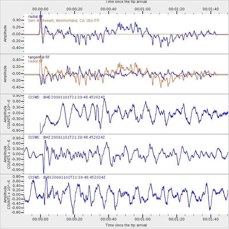
SWS Sam W. Stewart, Westmorland, CA, USA - Earthquake Result Viewer
*The percent match for this event was below the threshold and hence no stack was calculated.
| Earthquake location: |
Tonga Islands |
| Earthquake latitude/longitude: |
-15.5/-173.8 |
| Earthquake time(UTC): |
2009/11/01 (305) 21:28:58 GMT |
| Earthquake Depth: |
105 km |
| Earthquake Magnitude: |
5.8 MW, 5.4 MB, 5.8 MW |
| Earthquake Catalog/Contributor: |
WHDF/NEIC |
|
| Network: |
CI Caltech Regional Seismic Network |
| Station: |
SWS Sam W. Stewart, Westmorland, CA, USA |
| Lat/Lon: |
32.94 N/115.80 W |
| Elevation: |
140 m |
|
| Distance: |
73.4 deg |
| Az: |
48.068 deg |
| Baz: |
238.529 deg |
| Ray Param: |
$rayparam |
*The percent match for this event was below the threshold and hence was not used in the summary stack. |
|
| Radial Match: |
41.760902 % |
| Radial Bump: |
400 |
| Transverse Match: |
46.30141 % |
| Transverse Bump: |
391 |
| SOD ConfigId: |
2622 |
| Insert Time: |
2010-03-05 20:37:01.274 +0000 |
| GWidth: |
2.5 |
| Max Bumps: |
400 |
| Tol: |
0.001 |
|
Signal To Noise
| Channel | StoN | STA | LTA |
| CI:SWS: :BHZ:20091101T21:39:48.452024Z | 2.185561 | 4.3789868E-7 | 2.0035985E-7 |
| CI:SWS: :BHN:20091101T21:39:48.452024Z | 1.4070721 | 3.6562955E-7 | 2.598513E-7 |
| CI:SWS: :BHE:20091101T21:39:48.452024Z | 1.1885383 | 4.665999E-7 | 3.9258296E-7 |
| Arrivals |
| Ps | |
| PpPs | |
| PsPs/PpSs | |


