You are here: Home > Network List > CI - Caltech Regional Seismic Network Stations List
> Station SWS Sam W. Stewart, Westmorland, CA, USA > Earthquake Result Viewer
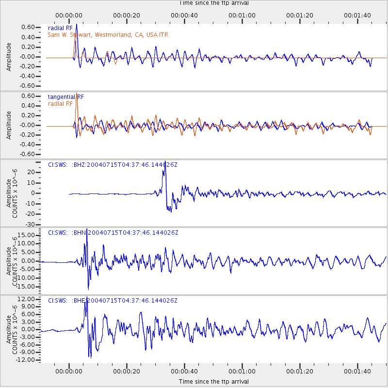
SWS Sam W. Stewart, Westmorland, CA, USA - Earthquake Result Viewer
*The percent match for this event was below the threshold and hence no stack was calculated.
| Earthquake location: |
Fiji Islands Region |
| Earthquake latitude/longitude: |
-17.6/-178.6 |
| Earthquake time(UTC): |
2004/07/15 (197) 04:27:12 GMT |
| Earthquake Depth: |
560 km |
| Earthquake Magnitude: |
5.5 MB |
| Earthquake Catalog/Contributor: |
WHDF/NEIC |
|
| Network: |
CI Caltech Regional Seismic Network |
| Station: |
SWS Sam W. Stewart, Westmorland, CA, USA |
| Lat/Lon: |
32.94 N/115.80 W |
| Elevation: |
140 m |
|
| Distance: |
78.3 deg |
| Az: |
49.819 deg |
| Baz: |
240.04 deg |
| Ray Param: |
$rayparam |
*The percent match for this event was below the threshold and hence was not used in the summary stack. |
|
| Radial Match: |
88.01606 % |
| Radial Bump: |
400 |
| Transverse Match: |
82.651985 % |
| Transverse Bump: |
400 |
| SOD ConfigId: |
2459 |
| Insert Time: |
2010-03-05 20:37:14.670 +0000 |
| GWidth: |
2.5 |
| Max Bumps: |
400 |
| Tol: |
0.001 |
|
Signal To Noise
| Channel | StoN | STA | LTA |
| CI:SWS: :BHN:20040715T04:37:46.144026Z | 1.865347 | 1.173741E-6 | 6.2923465E-7 |
| CI:SWS: :BHE:20040715T04:37:46.144026Z | 2.5433276 | 6.8473474E-7 | 2.692279E-7 |
| CI:SWS: :BHZ:20040715T04:37:46.144026Z | 23.969368 | 4.8513534E-6 | 2.0239806E-7 |
| Arrivals |
| Ps | |
| PpPs | |
| PsPs/PpSs | |


