You are here: Home > Network List > NE - New England Seismic Network Stations List
> Station PQI Presque Isle, ME, USA > Earthquake Result Viewer
PQI Presque Isle, ME, USA - Earthquake Result Viewer
| Earthquake location: |
Hindu Kush Region, Afghanistan |
| Earthquake latitude/longitude: |
36.4/70.7 |
| Earthquake time(UTC): |
2015/10/26 (299) 09:09:32 GMT |
| Earthquake Depth: |
212 km |
| Earthquake Magnitude: |
7.5 MWW, 7.5 MWB |
| Earthquake Catalog/Contributor: |
NEIC PDE/NEIC COMCAT |
|
| Network: |
NE New England Seismic Network |
| Station: |
PQI Presque Isle, ME, USA |
| Lat/Lon: |
46.67 N/68.02 W |
| Elevation: |
162 m |
|
| Distance: |
89.3 deg |
| Az: |
332.987 deg |
| Baz: |
32.132 deg |
| Ray Param: |
0.04170435 |
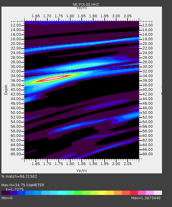
| Estimated Moho Depth: |
34.75 km |
| Estimated Crust Vp/Vs: |
1.73 |
| Assumed Crust Vp: |
6.419 km/s |
| Estimated Crust Vs: |
3.716 km/s |
| Estimated Crust Poisson's Ratio: |
0.25 |
|
| Radial Match: |
96.21582 % |
| Radial Bump: |
226 |
| Transverse Match: |
83.53475 % |
| Transverse Bump: |
400 |
| SOD ConfigId: |
1259291 |
| Insert Time: |
2015-11-09 09:55:02.262 +0000 |
| GWidth: |
2.5 |
| Max Bumps: |
400 |
| Tol: |
0.001 |
|

Signal To Noise
| Channel | StoN | STA | LTA |
| NE:PQI:00:HHZ:20151026T09:21:33.629019Z | 1.4638246 | 8.5506446E-7 | 5.8413036E-7 |
| NE:PQI:00:HH1:20151026T09:21:33.629019Z | 1.6196086 | 4.638639E-7 | 2.8640494E-7 |
| NE:PQI:00:HH2:20151026T09:21:33.629019Z | 1.1033381 | 4.2545935E-7 | 3.8561103E-7 |
| Arrivals |
| Ps | 4.0 SECOND |
| PpPs | 14 SECOND |
| PsPs/PpSs | 18 SECOND |


