You are here: Home > Network List > TA - USArray Transportable Network (new EarthScope stations) Stations List
> Station 109C Camp Elliot, Mirimar, CA, USA > Earthquake Result Viewer
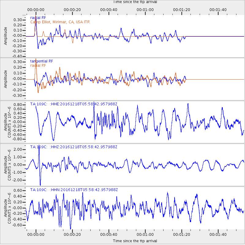
109C Camp Elliot, Mirimar, CA, USA - Earthquake Result Viewer
*The percent match for this event was below the threshold and hence no stack was calculated.
| Earthquake location: |
Solomon Islands |
| Earthquake latitude/longitude: |
-10.2/161.2 |
| Earthquake time(UTC): |
2016/12/18 (353) 05:46:25 GMT |
| Earthquake Depth: |
39 km |
| Earthquake Magnitude: |
6.0 Mwp |
| Earthquake Catalog/Contributor: |
NEIC PDE/us |
|
| Network: |
TA USArray Transportable Network (new EarthScope stations) |
| Station: |
109C Camp Elliot, Mirimar, CA, USA |
| Lat/Lon: |
32.89 N/117.11 W |
| Elevation: |
150 m |
|
| Distance: |
88.6 deg |
| Az: |
56.389 deg |
| Baz: |
256.98 deg |
| Ray Param: |
$rayparam |
*The percent match for this event was below the threshold and hence was not used in the summary stack. |
|
| Radial Match: |
61.204952 % |
| Radial Bump: |
400 |
| Transverse Match: |
52.602726 % |
| Transverse Bump: |
400 |
| SOD ConfigId: |
11737051 |
| Insert Time: |
2019-04-26 08:37:29.068 +0000 |
| GWidth: |
2.5 |
| Max Bumps: |
400 |
| Tol: |
0.001 |
|
Signal To Noise
| Channel | StoN | STA | LTA |
| TA:109C: :HHZ:20161218T05:58:42.957988Z | 2.6496754 | 1.0092231E-6 | 3.8088558E-7 |
| TA:109C: :HHN:20161218T05:58:42.957988Z | 0.7781388 | 1.6903257E-7 | 2.1722676E-7 |
| TA:109C: :HHE:20161218T05:58:42.957988Z | 1.2139595 | 3.9032477E-7 | 3.215303E-7 |
| Arrivals |
| Ps | |
| PpPs | |
| PsPs/PpSs | |


