You are here: Home > Network List > TA - USArray Transportable Network (new EarthScope stations) Stations List
> Station A36M Sachs Harbour, NT, CAN > Earthquake Result Viewer
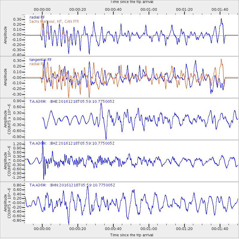
A36M Sachs Harbour, NT, CAN - Earthquake Result Viewer
*The percent match for this event was below the threshold and hence no stack was calculated.
| Earthquake location: |
Solomon Islands |
| Earthquake latitude/longitude: |
-10.2/161.2 |
| Earthquake time(UTC): |
2016/12/18 (353) 05:46:25 GMT |
| Earthquake Depth: |
39 km |
| Earthquake Magnitude: |
6.0 Mwp |
| Earthquake Catalog/Contributor: |
NEIC PDE/us |
|
| Network: |
TA USArray Transportable Network (new EarthScope stations) |
| Station: |
A36M Sachs Harbour, NT, CAN |
| Lat/Lon: |
71.99 N/125.25 W |
| Elevation: |
32 m |
|
| Distance: |
94.6 deg |
| Az: |
17.42 deg |
| Baz: |
251.294 deg |
| Ray Param: |
$rayparam |
*The percent match for this event was below the threshold and hence was not used in the summary stack. |
|
| Radial Match: |
63.104507 % |
| Radial Bump: |
400 |
| Transverse Match: |
56.29376 % |
| Transverse Bump: |
400 |
| SOD ConfigId: |
11737051 |
| Insert Time: |
2019-04-26 08:37:29.580 +0000 |
| GWidth: |
2.5 |
| Max Bumps: |
400 |
| Tol: |
0.001 |
|
Signal To Noise
| Channel | StoN | STA | LTA |
| TA:A36M: :BHZ:20161218T05:59:10.775005Z | 2.8000045 | 5.230262E-7 | 1.8679476E-7 |
| TA:A36M: :BHN:20161218T05:59:10.775005Z | 1.1496445 | 2.735705E-7 | 2.3796095E-7 |
| TA:A36M: :BHE:20161218T05:59:10.775005Z | 1.8659099 | 3.4848185E-7 | 1.867624E-7 |
| Arrivals |
| Ps | |
| PpPs | |
| PsPs/PpSs | |


