You are here: Home > Network List > CI - Caltech Regional Seismic Network Stations List
> Station SWS Sam W. Stewart, Westmorland, CA, USA > Earthquake Result Viewer
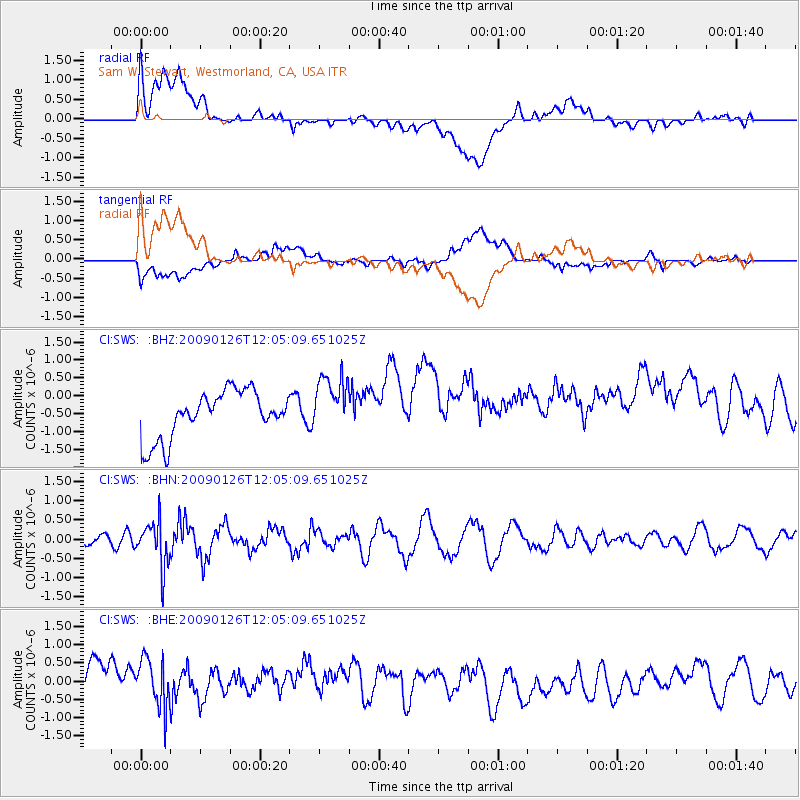
SWS Sam W. Stewart, Westmorland, CA, USA - Earthquake Result Viewer
*The percent match for this event was below the threshold and hence no stack was calculated.
| Earthquake location: |
Fiji Islands Region |
| Earthquake latitude/longitude: |
-17.8/-178.6 |
| Earthquake time(UTC): |
2009/01/26 (026) 11:54:39 GMT |
| Earthquake Depth: |
580 km |
| Earthquake Magnitude: |
5.5 MB, 5.8 MW, 5.8 MW |
| Earthquake Catalog/Contributor: |
WHDF/NEIC |
|
| Network: |
CI Caltech Regional Seismic Network |
| Station: |
SWS Sam W. Stewart, Westmorland, CA, USA |
| Lat/Lon: |
32.94 N/115.80 W |
| Elevation: |
140 m |
|
| Distance: |
78.4 deg |
| Az: |
49.782 deg |
| Baz: |
239.901 deg |
| Ray Param: |
$rayparam |
*The percent match for this event was below the threshold and hence was not used in the summary stack. |
|
| Radial Match: |
40.091366 % |
| Radial Bump: |
400 |
| Transverse Match: |
45.292007 % |
| Transverse Bump: |
400 |
| SOD ConfigId: |
2658 |
| Insert Time: |
2010-03-05 20:38:25.895 +0000 |
| GWidth: |
2.5 |
| Max Bumps: |
400 |
| Tol: |
0.001 |
|
Signal To Noise
| Channel | StoN | STA | LTA |
| CI:SWS: :BHN:20090126T12:05:09.651025Z | 3.7689705 | 5.8393164E-7 | 1.5493133E-7 |
| CI:SWS: :BHE:20090126T12:05:09.651025Z | 0.9040393 | 9.458172E-7 | 1.0462124E-6 |
| CI:SWS: :BHZ:20090126T12:05:09.651025Z | 1.2434117 | 8.140554E-7 | 6.5469504E-7 |
| Arrivals |
| Ps | |
| PpPs | |
| PsPs/PpSs | |


