You are here: Home > Network List > TA - USArray Transportable Network (new EarthScope stations) Stations List
> Station G23K Bananza Creek, AK, USA > Earthquake Result Viewer
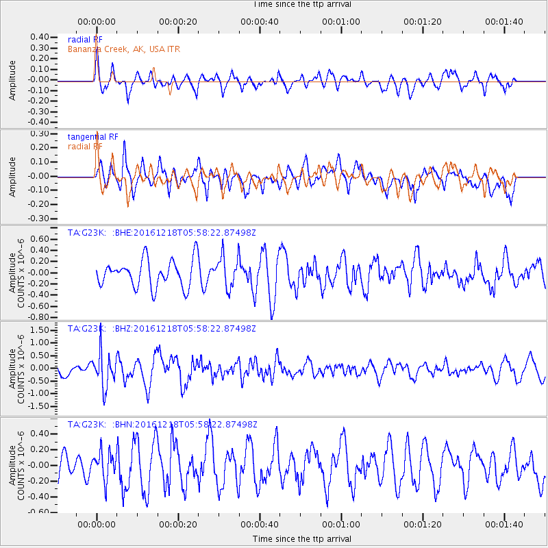
G23K Bananza Creek, AK, USA - Earthquake Result Viewer
*The percent match for this event was below the threshold and hence no stack was calculated.
| Earthquake location: |
Solomon Islands |
| Earthquake latitude/longitude: |
-10.2/161.2 |
| Earthquake time(UTC): |
2016/12/18 (353) 05:46:25 GMT |
| Earthquake Depth: |
39 km |
| Earthquake Magnitude: |
6.0 Mwp |
| Earthquake Catalog/Contributor: |
NEIC PDE/us |
|
| Network: |
TA USArray Transportable Network (new EarthScope stations) |
| Station: |
G23K Bananza Creek, AK, USA |
| Lat/Lon: |
66.71 N/150.02 W |
| Elevation: |
746 m |
|
| Distance: |
84.5 deg |
| Az: |
17.486 deg |
| Baz: |
228.059 deg |
| Ray Param: |
$rayparam |
*The percent match for this event was below the threshold and hence was not used in the summary stack. |
|
| Radial Match: |
70.27205 % |
| Radial Bump: |
400 |
| Transverse Match: |
54.94532 % |
| Transverse Bump: |
400 |
| SOD ConfigId: |
11737051 |
| Insert Time: |
2019-04-26 08:37:46.412 +0000 |
| GWidth: |
2.5 |
| Max Bumps: |
400 |
| Tol: |
0.001 |
|
Signal To Noise
| Channel | StoN | STA | LTA |
| TA:G23K: :BHZ:20161218T05:58:22.87498Z | 2.8863733 | 6.7653434E-7 | 2.3438908E-7 |
| TA:G23K: :BHN:20161218T05:58:22.87498Z | 0.88466626 | 1.7797922E-7 | 2.0118233E-7 |
| TA:G23K: :BHE:20161218T05:58:22.87498Z | 1.1805104 | 2.8590028E-7 | 2.4218363E-7 |
| Arrivals |
| Ps | |
| PpPs | |
| PsPs/PpSs | |


