You are here: Home > Network List > TA - USArray Transportable Network (new EarthScope stations) Stations List
> Station J26L Joseph Creek, AK, USA > Earthquake Result Viewer
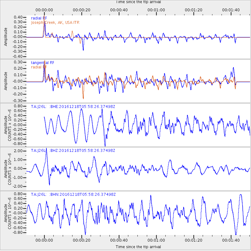
J26L Joseph Creek, AK, USA - Earthquake Result Viewer
*The percent match for this event was below the threshold and hence no stack was calculated.
| Earthquake location: |
Solomon Islands |
| Earthquake latitude/longitude: |
-10.2/161.2 |
| Earthquake time(UTC): |
2016/12/18 (353) 05:46:25 GMT |
| Earthquake Depth: |
39 km |
| Earthquake Magnitude: |
6.0 Mwp |
| Earthquake Catalog/Contributor: |
NEIC PDE/us |
|
| Network: |
TA USArray Transportable Network (new EarthScope stations) |
| Station: |
J26L Joseph Creek, AK, USA |
| Lat/Lon: |
64.50 N/143.56 W |
| Elevation: |
1144 m |
|
| Distance: |
85.2 deg |
| Az: |
20.908 deg |
| Baz: |
234.246 deg |
| Ray Param: |
$rayparam |
*The percent match for this event was below the threshold and hence was not used in the summary stack. |
|
| Radial Match: |
58.02939 % |
| Radial Bump: |
400 |
| Transverse Match: |
55.986214 % |
| Transverse Bump: |
400 |
| SOD ConfigId: |
11737051 |
| Insert Time: |
2019-04-26 08:37:59.281 +0000 |
| GWidth: |
2.5 |
| Max Bumps: |
400 |
| Tol: |
0.001 |
|
Signal To Noise
| Channel | StoN | STA | LTA |
| TA:J26L: :BHZ:20161218T05:58:26.37498Z | 3.3167493 | 9.751637E-7 | 2.940119E-7 |
| TA:J26L: :BHN:20161218T05:58:26.37498Z | 1.0547562 | 2.5895991E-7 | 2.455164E-7 |
| TA:J26L: :BHE:20161218T05:58:26.37498Z | 1.1925508 | 4.4622365E-7 | 3.741758E-7 |
| Arrivals |
| Ps | |
| PpPs | |
| PsPs/PpSs | |


