You are here: Home > Network List > CI - Caltech Regional Seismic Network Stations List
> Station SWS Sam W. Stewart, Westmorland, CA, USA > Earthquake Result Viewer
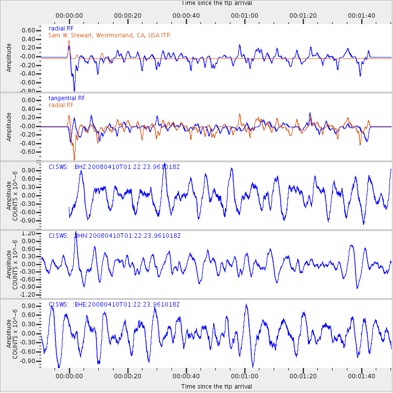
SWS Sam W. Stewart, Westmorland, CA, USA - Earthquake Result Viewer
*The percent match for this event was below the threshold and hence no stack was calculated.
| Earthquake location: |
Loyalty Islands |
| Earthquake latitude/longitude: |
-20.3/168.9 |
| Earthquake time(UTC): |
2008/04/10 (101) 01:10:02 GMT |
| Earthquake Depth: |
35 km |
| Earthquake Magnitude: |
5.5 MB, 5.5 MS, 5.8 MW |
| Earthquake Catalog/Contributor: |
WHDF/NEIC |
|
| Network: |
CI Caltech Regional Seismic Network |
| Station: |
SWS Sam W. Stewart, Westmorland, CA, USA |
| Lat/Lon: |
32.94 N/115.80 W |
| Elevation: |
140 m |
|
| Distance: |
89.2 deg |
| Az: |
54.422 deg |
| Baz: |
245.185 deg |
| Ray Param: |
$rayparam |
*The percent match for this event was below the threshold and hence was not used in the summary stack. |
|
| Radial Match: |
78.46083 % |
| Radial Bump: |
400 |
| Transverse Match: |
42.587456 % |
| Transverse Bump: |
400 |
| SOD ConfigId: |
2504 |
| Insert Time: |
2010-03-05 20:38:34.476 +0000 |
| GWidth: |
2.5 |
| Max Bumps: |
400 |
| Tol: |
0.001 |
|
Signal To Noise
| Channel | StoN | STA | LTA |
| CI:SWS: :BHN:20080410T01:22:23.961018Z | 2.8651693 | 5.3217195E-7 | 1.8573839E-7 |
| CI:SWS: :BHE:20080410T01:22:23.961018Z | 1.1685793 | 3.9086552E-7 | 3.3447927E-7 |
| CI:SWS: :BHZ:20080410T01:22:23.961018Z | 1.5440413 | 5.866045E-7 | 3.79915E-7 |
| Arrivals |
| Ps | |
| PpPs | |
| PsPs/PpSs | |


