You are here: Home > Network List > CI - Caltech Regional Seismic Network Stations List
> Station SDD SDD, Mission Viejo, CA, USA > Earthquake Result Viewer
SDD SDD, Mission Viejo, CA, USA - Earthquake Result Viewer
| Earthquake location: |
Kodiak Island Region, Alaska |
| Earthquake latitude/longitude: |
57.4/-154.5 |
| Earthquake time(UTC): |
1999/12/07 (341) 00:19:49 GMT |
| Earthquake Depth: |
41 km |
| Earthquake Magnitude: |
6.5 MB, 6.1 MS, 6.4 MW, 6.3 ML |
| Earthquake Catalog/Contributor: |
WHDF/NEIC |
|
| Network: |
CI Caltech Regional Seismic Network |
| Station: |
SDD SDD, Mission Viejo, CA, USA |
| Lat/Lon: |
33.55 N/117.66 W |
| Elevation: |
120 m |
|
| Distance: |
34.5 deg |
| Az: |
117.748 deg |
| Baz: |
324.95 deg |
| Ray Param: |
0.07763988 |
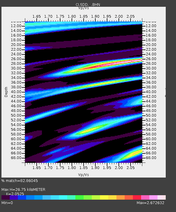
| Estimated Moho Depth: |
26.75 km |
| Estimated Crust Vp/Vs: |
2.05 |
| Assumed Crust Vp: |
6.264 km/s |
| Estimated Crust Vs: |
3.052 km/s |
| Estimated Crust Poisson's Ratio: |
0.34 |
|
| Radial Match: |
82.86045 % |
| Radial Bump: |
400 |
| Transverse Match: |
84.90301 % |
| Transverse Bump: |
400 |
| SOD ConfigId: |
3787 |
| Insert Time: |
2010-02-26 00:57:04.573 +0000 |
| GWidth: |
2.5 |
| Max Bumps: |
400 |
| Tol: |
0.001 |
|

Signal To Noise
| Channel | StoN | STA | LTA |
| CI:SDD: :BHN:19991207T00:26:03.185012Z | 1.2787813 | 2.7488243E-6 | 2.1495657E-6 |
| CI:SDD: :BHE:19991207T00:26:03.185012Z | 0.84458995 | 1.8460436E-6 | 2.1857275E-6 |
| CI:SDD: :BHZ:19991207T00:26:03.185012Z | 2.846029 | 6.290588E-6 | 2.2103034E-6 |
| Arrivals |
| Ps | 4.8 SECOND |
| PpPs | 12 SECOND |
| PsPs/PpSs | 17 SECOND |


