You are here: Home > Network List > UW - Pacific Northwest Regional Seismic Network Stations List
> Station UMAT Pilot Rock, OR, USA > Earthquake Result Viewer
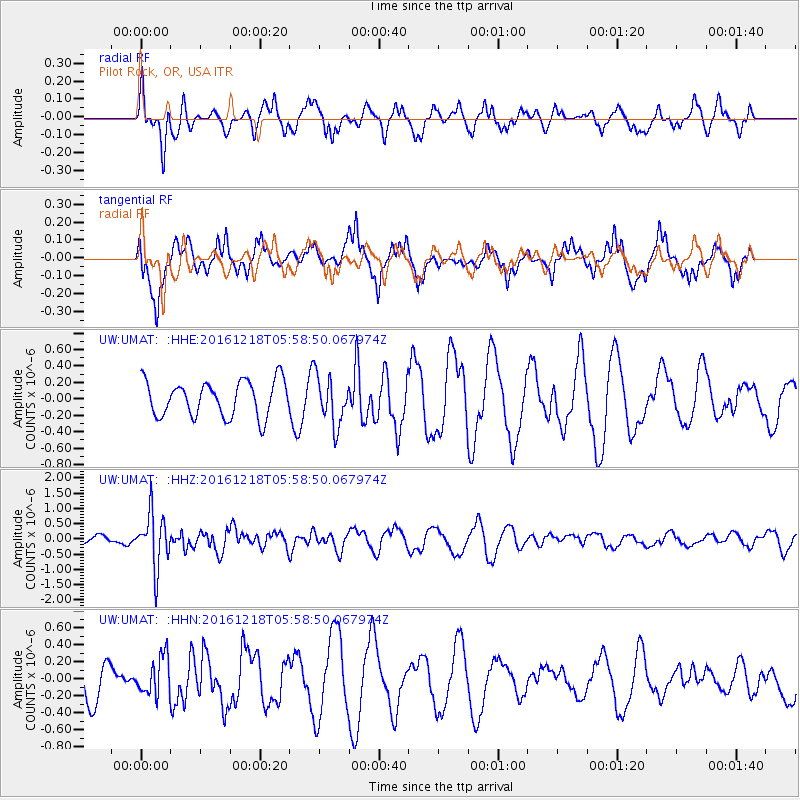
UMAT Pilot Rock, OR, USA - Earthquake Result Viewer
*The percent match for this event was below the threshold and hence no stack was calculated.
| Earthquake location: |
Solomon Islands |
| Earthquake latitude/longitude: |
-10.2/161.2 |
| Earthquake time(UTC): |
2016/12/18 (353) 05:46:25 GMT |
| Earthquake Depth: |
39 km |
| Earthquake Magnitude: |
6.0 Mwp |
| Earthquake Catalog/Contributor: |
NEIC PDE/us |
|
| Network: |
UW Pacific Northwest Regional Seismic Network |
| Station: |
UMAT Pilot Rock, OR, USA |
| Lat/Lon: |
45.29 N/118.96 W |
| Elevation: |
1318 m |
|
| Distance: |
90.1 deg |
| Az: |
44.015 deg |
| Baz: |
255.674 deg |
| Ray Param: |
$rayparam |
*The percent match for this event was below the threshold and hence was not used in the summary stack. |
|
| Radial Match: |
56.328545 % |
| Radial Bump: |
388 |
| Transverse Match: |
73.33435 % |
| Transverse Bump: |
347 |
| SOD ConfigId: |
11737051 |
| Insert Time: |
2019-04-26 08:39:17.538 +0000 |
| GWidth: |
2.5 |
| Max Bumps: |
400 |
| Tol: |
0.001 |
|
Signal To Noise
| Channel | StoN | STA | LTA |
| UW:UMAT: :HHZ:20161218T05:58:50.067974Z | 4.108786 | 8.7614234E-7 | 2.132363E-7 |
| UW:UMAT: :HHN:20161218T05:58:50.067974Z | 1.2084341 | 2.2788424E-7 | 1.8857811E-7 |
| UW:UMAT: :HHE:20161218T05:58:50.067974Z | 1.3808382 | 2.970035E-7 | 2.150893E-7 |
| Arrivals |
| Ps | |
| PpPs | |
| PsPs/PpSs | |


