You are here: Home > Network List > YT07 - POLENET Stations List
> Station SILY SILY > Earthquake Result Viewer
SILY SILY - Earthquake Result Viewer
| Earthquake location: |
Solomon Islands |
| Earthquake latitude/longitude: |
-10.2/161.2 |
| Earthquake time(UTC): |
2016/12/18 (353) 05:46:25 GMT |
| Earthquake Depth: |
39 km |
| Earthquake Magnitude: |
6.0 Mwp |
| Earthquake Catalog/Contributor: |
NEIC PDE/us |
|
| Network: |
YT POLENET |
| Station: |
SILY SILY |
| Lat/Lon: |
77.13 S/125.97 W |
| Elevation: |
2093 m |
|
| Distance: |
76.3 deg |
| Az: |
167.267 deg |
| Baz: |
284.516 deg |
| Ray Param: |
0.051031265 |
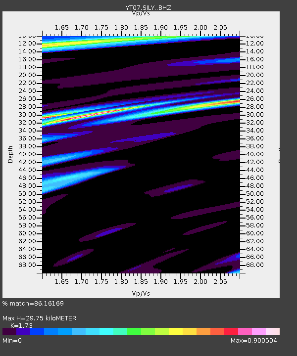
| Estimated Moho Depth: |
29.75 km |
| Estimated Crust Vp/Vs: |
1.73 |
| Assumed Crust Vp: |
6.138 km/s |
| Estimated Crust Vs: |
3.548 km/s |
| Estimated Crust Poisson's Ratio: |
0.25 |
|
| Radial Match: |
86.16169 % |
| Radial Bump: |
400 |
| Transverse Match: |
82.76334 % |
| Transverse Bump: |
400 |
| SOD ConfigId: |
11737051 |
| Insert Time: |
2019-04-26 08:40:25.611 +0000 |
| GWidth: |
2.5 |
| Max Bumps: |
400 |
| Tol: |
0.001 |
|

Signal To Noise
| Channel | StoN | STA | LTA |
| YT:SILY: :BHZ:20161218T05:57:39.025005Z | 17.944412 | 2.7437666E-6 | 1.5290367E-7 |
| YT:SILY: :BHN:20161218T05:57:39.025005Z | 4.431495 | 5.1088017E-7 | 1.15283925E-7 |
| YT:SILY: :BHE:20161218T05:57:39.025005Z | 10.794877 | 8.295969E-7 | 7.685098E-8 |
| Arrivals |
| Ps | 3.6 SECOND |
| PpPs | 13 SECOND |
| PsPs/PpSs | 16 SECOND |


