You are here: Home > Network List > IU - Global Seismograph Network (GSN - IRIS/USGS) Stations List
> Station POHA Pohakuloa, Hawaii, USA > Earthquake Result Viewer
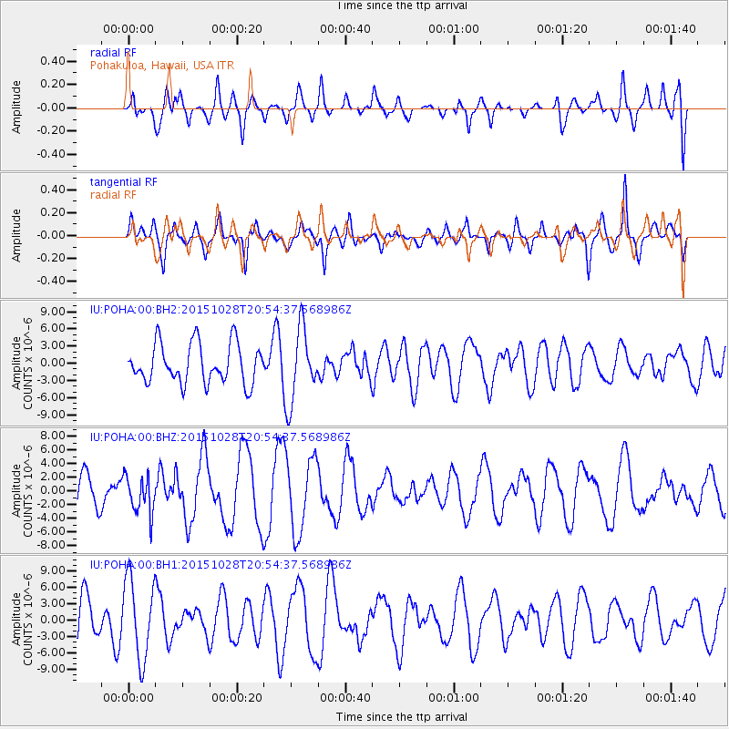
POHA Pohakuloa, Hawaii, USA - Earthquake Result Viewer
*The percent match for this event was below the threshold and hence no stack was calculated.
| Earthquake location: |
Santa Cruz Islands |
| Earthquake latitude/longitude: |
-11.0/166.4 |
| Earthquake time(UTC): |
2015/10/28 (301) 20:46:41 GMT |
| Earthquake Depth: |
152 km |
| Earthquake Magnitude: |
5.8 MWB |
| Earthquake Catalog/Contributor: |
NEIC PDE/NEIC COMCAT |
|
| Network: |
IU Global Seismograph Network (GSN - IRIS/USGS) |
| Station: |
POHA Pohakuloa, Hawaii, USA |
| Lat/Lon: |
19.76 N/155.53 W |
| Elevation: |
1990 m |
|
| Distance: |
48.4 deg |
| Az: |
51.017 deg |
| Baz: |
234.136 deg |
| Ray Param: |
$rayparam |
*The percent match for this event was below the threshold and hence was not used in the summary stack. |
|
| Radial Match: |
47.47853 % |
| Radial Bump: |
400 |
| Transverse Match: |
54.60998 % |
| Transverse Bump: |
400 |
| SOD ConfigId: |
1259291 |
| Insert Time: |
2015-11-11 21:09:36.803 +0000 |
| GWidth: |
2.5 |
| Max Bumps: |
400 |
| Tol: |
0.001 |
|
Signal To Noise
| Channel | StoN | STA | LTA |
| IU:POHA:00:BHZ:20151028T20:54:37.568986Z | 1.2062565 | 2.714799E-6 | 2.2505983E-6 |
| IU:POHA:00:BH1:20151028T20:54:37.568986Z | 1.7391341 | 7.468268E-6 | 4.2942447E-6 |
| IU:POHA:00:BH2:20151028T20:54:37.568986Z | 1.8717523 | 6.4327096E-6 | 3.4367313E-6 |
| Arrivals |
| Ps | |
| PpPs | |
| PsPs/PpSs | |


