You are here: Home > Network List > CI - Caltech Regional Seismic Network Stations List
> Station SWS Sam W. Stewart, Westmorland, CA, USA > Earthquake Result Viewer
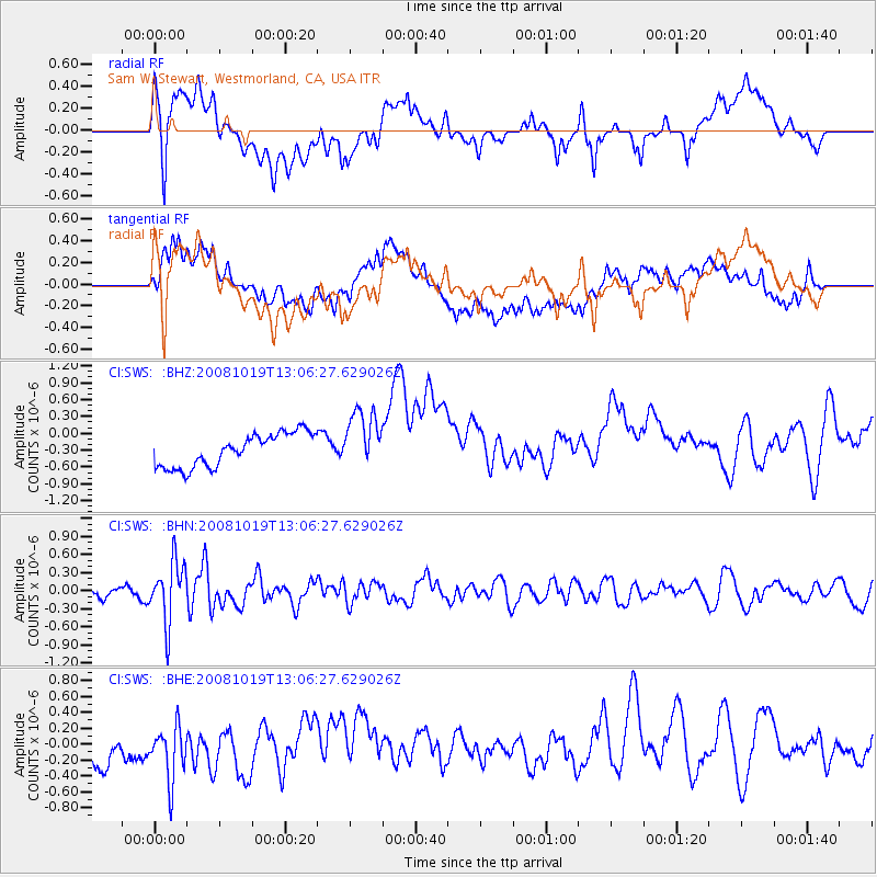
SWS Sam W. Stewart, Westmorland, CA, USA - Earthquake Result Viewer
*The percent match for this event was below the threshold and hence no stack was calculated.
| Earthquake location: |
Tonga Islands |
| Earthquake latitude/longitude: |
-22.0/-173.7 |
| Earthquake time(UTC): |
2008/10/19 (293) 12:55:05 GMT |
| Earthquake Depth: |
35 km |
| Earthquake Magnitude: |
5.7 MB, 5.3 MS, 5.6 MW, 5.5 MW |
| Earthquake Catalog/Contributor: |
WHDF/NEIC |
|
| Network: |
CI Caltech Regional Seismic Network |
| Station: |
SWS Sam W. Stewart, Westmorland, CA, USA |
| Lat/Lon: |
32.94 N/115.80 W |
| Elevation: |
140 m |
|
| Distance: |
77.7 deg |
| Az: |
46.817 deg |
| Baz: |
233.601 deg |
| Ray Param: |
$rayparam |
*The percent match for this event was below the threshold and hence was not used in the summary stack. |
|
| Radial Match: |
40.16629 % |
| Radial Bump: |
400 |
| Transverse Match: |
22.91773 % |
| Transverse Bump: |
400 |
| SOD ConfigId: |
2556 |
| Insert Time: |
2010-03-05 20:38:57.429 +0000 |
| GWidth: |
2.5 |
| Max Bumps: |
400 |
| Tol: |
0.001 |
|
Signal To Noise
| Channel | StoN | STA | LTA |
| CI:SWS: :BHN:20081019T13:06:27.629026Z | 5.4017406 | 4.9598617E-7 | 9.18197E-8 |
| CI:SWS: :BHE:20081019T13:06:27.629026Z | 0.92275816 | 4.3930746E-7 | 4.7608083E-7 |
| CI:SWS: :BHZ:20081019T13:06:27.629026Z | 1.7770864 | 5.241015E-7 | 2.949218E-7 |
| Arrivals |
| Ps | |
| PpPs | |
| PsPs/PpSs | |


