You are here: Home > Network List > CI - Caltech Regional Seismic Network Stations List
> Station BEL Belle Mtn, Joshua Tree National Park, CA, USA > Earthquake Result Viewer
BEL Belle Mtn, Joshua Tree National Park, CA, USA - Earthquake Result Viewer
| Earthquake location: |
South Pacific Ocean |
| Earthquake latitude/longitude: |
-20.3/-126.9 |
| Earthquake time(UTC): |
2004/07/11 (193) 23:46:12 GMT |
| Earthquake Depth: |
12 km |
| Earthquake Magnitude: |
6.1 MB, 5.9 MS, 6.1 MW, 6.1 MW |
| Earthquake Catalog/Contributor: |
WHDF/NEIC |
|
| Network: |
CI Caltech Regional Seismic Network |
| Station: |
BEL Belle Mtn, Joshua Tree National Park, CA, USA |
| Lat/Lon: |
34.00 N/116.00 W |
| Elevation: |
1388 m |
|
| Distance: |
54.9 deg |
| Az: |
11.094 deg |
| Baz: |
192.561 deg |
| Ray Param: |
0.06511508 |
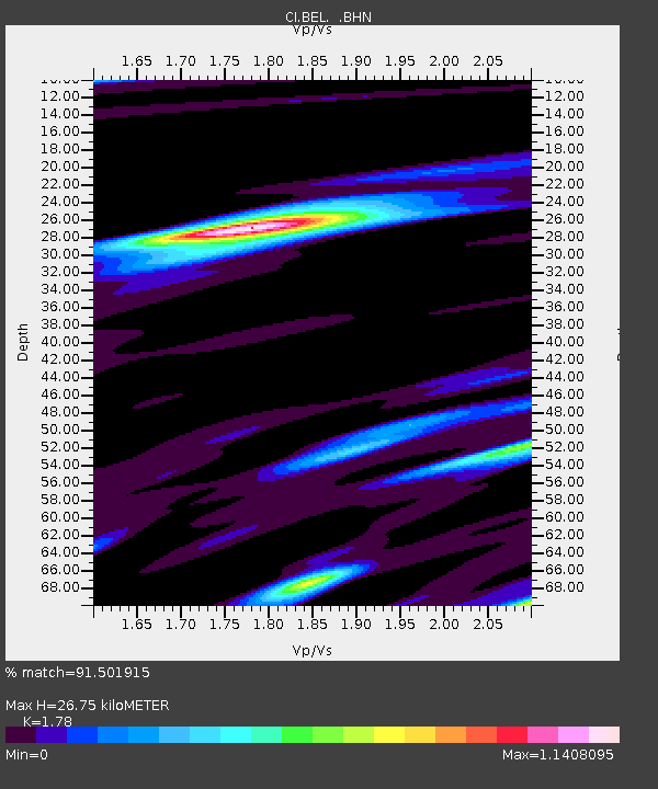
| Estimated Moho Depth: |
26.75 km |
| Estimated Crust Vp/Vs: |
1.78 |
| Assumed Crust Vp: |
6.276 km/s |
| Estimated Crust Vs: |
3.526 km/s |
| Estimated Crust Poisson's Ratio: |
0.27 |
|
| Radial Match: |
91.501915 % |
| Radial Bump: |
400 |
| Transverse Match: |
78.50547 % |
| Transverse Bump: |
400 |
| SOD ConfigId: |
2459 |
| Insert Time: |
2010-03-05 20:39:23.017 +0000 |
| GWidth: |
2.5 |
| Max Bumps: |
400 |
| Tol: |
0.001 |
|
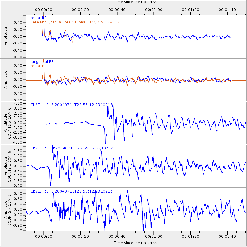
Signal To Noise
| Channel | StoN | STA | LTA |
| CI:BEL: :BHN:20040711T23:55:12.231021Z | 5.4642434 | 6.533019E-7 | 1.1955945E-7 |
| CI:BEL: :BHE:20040711T23:55:12.231021Z | 1.9574878 | 2.5562133E-7 | 1.3058641E-7 |
| CI:BEL: :BHZ:20040711T23:55:12.231021Z | 9.647629 | 1.5668454E-6 | 1.624073E-7 |
| Arrivals |
| Ps | 3.5 SECOND |
| PpPs | 11 SECOND |
| PsPs/PpSs | 15 SECOND |


