You are here: Home > Network List > CI - Caltech Regional Seismic Network Stations List
> Station BEL Belle Mtn, Joshua Tree National Park, CA, USA > Earthquake Result Viewer
BEL Belle Mtn, Joshua Tree National Park, CA, USA - Earthquake Result Viewer
| Earthquake location: |
Kamchatka Peninsula, Russia |
| Earthquake latitude/longitude: |
55.7/160.0 |
| Earthquake time(UTC): |
2004/06/10 (162) 15:19:57 GMT |
| Earthquake Depth: |
189 km |
| Earthquake Magnitude: |
6.1 MB, 6.9 MW, 6.9 MW |
| Earthquake Catalog/Contributor: |
WHDF/NEIC |
|
| Network: |
CI Caltech Regional Seismic Network |
| Station: |
BEL Belle Mtn, Joshua Tree National Park, CA, USA |
| Lat/Lon: |
34.00 N/116.00 W |
| Elevation: |
1388 m |
|
| Distance: |
59.5 deg |
| Az: |
73.568 deg |
| Baz: |
319.164 deg |
| Ray Param: |
0.061560877 |
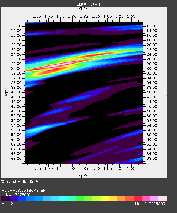
| Estimated Moho Depth: |
28.25 km |
| Estimated Crust Vp/Vs: |
1.74 |
| Assumed Crust Vp: |
6.276 km/s |
| Estimated Crust Vs: |
3.612 km/s |
| Estimated Crust Poisson's Ratio: |
0.25 |
|
| Radial Match: |
96.96509 % |
| Radial Bump: |
400 |
| Transverse Match: |
85.42893 % |
| Transverse Bump: |
400 |
| SOD ConfigId: |
2459 |
| Insert Time: |
2010-03-05 20:39:26.280 +0000 |
| GWidth: |
2.5 |
| Max Bumps: |
400 |
| Tol: |
0.001 |
|
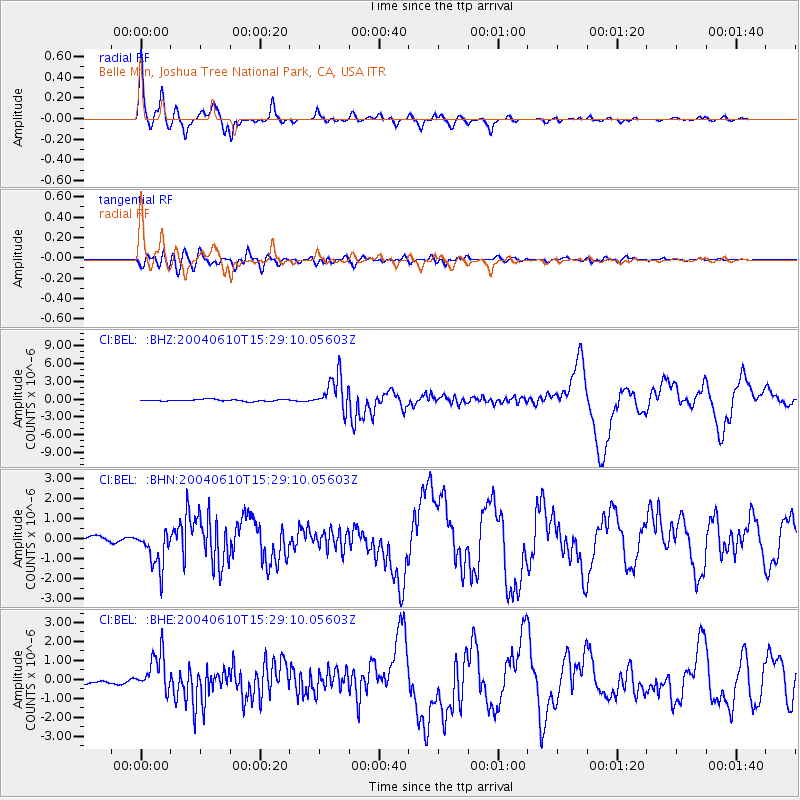
Signal To Noise
| Channel | StoN | STA | LTA |
| CI:BEL: :BHN:20040610T15:29:10.05603Z | 7.025829 | 9.880617E-7 | 1.4063276E-7 |
| CI:BEL: :BHE:20040610T15:29:10.05603Z | 9.661469 | 1.0121574E-6 | 1.04762265E-7 |
| CI:BEL: :BHZ:20040610T15:29:10.05603Z | 20.925213 | 2.8961501E-6 | 1.3840481E-7 |
| Arrivals |
| Ps | 3.5 SECOND |
| PpPs | 12 SECOND |
| PsPs/PpSs | 15 SECOND |


